You are here: Home > Network List > CN - Canadian National Seismograph Network Stations List
> Station BRWY Burwash Landing, YT, CA > Earthquake Result Viewer
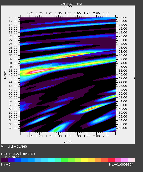
BRWY Burwash Landing, YT, CA - Earthquake Result Viewer
| Earthquake location: |
Near Coast Of Guerrero, Mexico |
| Earthquake latitude/longitude: |
17.0/-99.8 |
| Earthquake time(UTC): |
2021/09/08 (251) 01:47:46 GMT |
| Earthquake Depth: |
13 km |
| Earthquake Magnitude: |
7.0 mww |
| Earthquake Catalog/Contributor: |
NEIC PDE/us |
|
| Network: |
CN Canadian National Seismograph Network |
| Station: |
BRWY Burwash Landing, YT, CA |
| Lat/Lon: |
61.37 N/139.03 W |
| Elevation: |
802 m |
|
| Distance: |
52.3 deg |
| Az: |
337.364 deg |
| Baz: |
130.108 deg |
| Ray Param: |
0.06680754 |
| Estimated Moho Depth: |
38.0 km |
| Estimated Crust Vp/Vs: |
1.69 |
| Assumed Crust Vp: |
6.566 km/s |
| Estimated Crust Vs: |
3.88 km/s |
| Estimated Crust Poisson's Ratio: |
0.23 |
|
| Radial Match: |
91.565 % |
| Radial Bump: |
400 |
| Transverse Match: |
83.848145 % |
| Transverse Bump: |
400 |
| SOD ConfigId: |
25131211 |
| Insert Time: |
2021-09-22 02:00:06.741 +0000 |
| GWidth: |
2.5 |
| Max Bumps: |
400 |
| Tol: |
0.001 |
|

Signal To Noise
| Channel | StoN | STA | LTA |
| CN:BRWY: :HHZ:20210908T01:56:27.420006Z | 53.93811 | 7.4845316E-6 | 1.3876146E-7 |
| CN:BRWY: :HHN:20210908T01:56:27.420006Z | 18.197187 | 2.497449E-6 | 1.3724367E-7 |
| CN:BRWY: :HHE:20210908T01:56:27.420006Z | 18.515179 | 2.790772E-6 | 1.5072888E-7 |
| Arrivals |
| Ps | 4.3 SECOND |
| PpPs | 15 SECOND |
| PsPs/PpSs | 19 SECOND |


