You are here: Home > Network List > CN - Canadian National Seismograph Network Stations List
> Station OZB Mt. Ozzard, BC, CA > Earthquake Result Viewer
OZB Mt. Ozzard, BC, CA - Earthquake Result Viewer
| Earthquake location: |
Near Coast Of Guerrero, Mexico |
| Earthquake latitude/longitude: |
17.0/-99.8 |
| Earthquake time(UTC): |
2021/09/08 (251) 01:47:46 GMT |
| Earthquake Depth: |
13 km |
| Earthquake Magnitude: |
7.0 mww |
| Earthquake Catalog/Contributor: |
NEIC PDE/us |
|
| Network: |
CN Canadian National Seismograph Network |
| Station: |
OZB Mt. Ozzard, BC, CA |
| Lat/Lon: |
48.96 N/125.50 W |
| Elevation: |
614 m |
|
| Distance: |
38.2 deg |
| Az: |
332.436 deg |
| Baz: |
137.78 deg |
| Ray Param: |
0.07573152 |
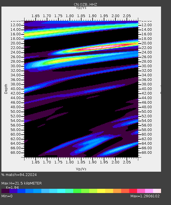
| Estimated Moho Depth: |
21.5 km |
| Estimated Crust Vp/Vs: |
1.94 |
| Assumed Crust Vp: |
6.391 km/s |
| Estimated Crust Vs: |
3.294 km/s |
| Estimated Crust Poisson's Ratio: |
0.32 |
|
| Radial Match: |
94.22024 % |
| Radial Bump: |
286 |
| Transverse Match: |
83.2773 % |
| Transverse Bump: |
400 |
| SOD ConfigId: |
25131211 |
| Insert Time: |
2021-09-22 02:01:24.801 +0000 |
| GWidth: |
2.5 |
| Max Bumps: |
400 |
| Tol: |
0.001 |
|

Signal To Noise
| Channel | StoN | STA | LTA |
| CN:OZB: :HHZ:20210908T01:54:35.089989Z | 35.493538 | 9.5469195E-6 | 2.689763E-7 |
| CN:OZB: :HHN:20210908T01:54:35.089989Z | 10.577317 | 3.856101E-6 | 3.6456328E-7 |
| CN:OZB: :HHE:20210908T01:54:35.089989Z | 18.410366 | 4.7770445E-6 | 2.5947583E-7 |
| Arrivals |
| Ps | 3.4 SECOND |
| PpPs | 9.3 SECOND |
| PsPs/PpSs | 13 SECOND |


