You are here: Home > Network List > XS99 - Montana BB Array Stations List
> Station S21 XS.S21 > Earthquake Result Viewer
S21 XS.S21 - Earthquake Result Viewer
| Earthquake location: |
Chile-Argentina Border Region |
| Earthquake latitude/longitude: |
-33.9/-70.1 |
| Earthquake time(UTC): |
2000/06/16 (168) 07:55:35 GMT |
| Earthquake Depth: |
120 km |
| Earthquake Magnitude: |
6.2 MB, 6.5 MW, 6.1 MD |
| Earthquake Catalog/Contributor: |
WHDF/NEIC |
|
| Network: |
XS Montana BB Array |
| Station: |
S21 XS.S21 |
| Lat/Lon: |
45.95 N/108.60 W |
| Elevation: |
1800 m |
|
| Distance: |
86.7 deg |
| Az: |
334.206 deg |
| Baz: |
148.743 deg |
| Ray Param: |
0.04356296 |
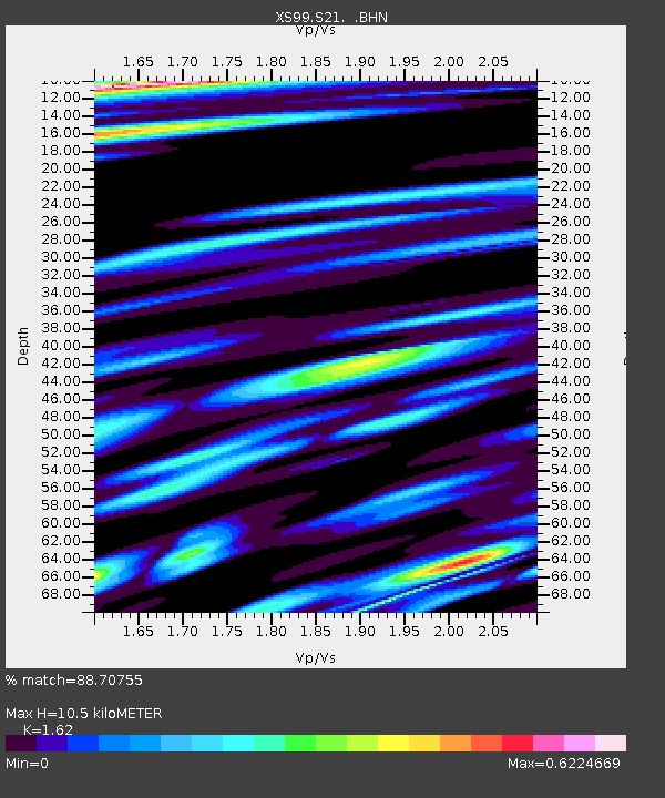
| Estimated Moho Depth: |
10.5 km |
| Estimated Crust Vp/Vs: |
1.62 |
| Assumed Crust Vp: |
6.242 km/s |
| Estimated Crust Vs: |
3.853 km/s |
| Estimated Crust Poisson's Ratio: |
0.19 |
|
| Radial Match: |
88.70755 % |
| Radial Bump: |
400 |
| Transverse Match: |
79.04498 % |
| Transverse Bump: |
400 |
| SOD ConfigId: |
20082 |
| Insert Time: |
2010-03-09 12:36:54.847 +0000 |
| GWidth: |
2.5 |
| Max Bumps: |
400 |
| Tol: |
0.001 |
|

Signal To Noise
| Channel | StoN | STA | LTA |
| XS:S21: :BHN:20000616T08:07:34.77501Z | 3.839486 | 9.914435E-7 | 2.5822297E-7 |
| XS:S21: :BHE:20000616T08:07:34.77501Z | 1.7819815 | 5.7544884E-7 | 3.2292638E-7 |
| XS:S21: :BHZ:20000616T08:07:34.77501Z | 10.119162 | 6.261789E-6 | 6.1880513E-7 |
| Arrivals |
| Ps | 1.1 SECOND |
| PpPs | 4.3 SECOND |
| PsPs/PpSs | 5.4 SECOND |


