You are here: Home > Network List > CN - Canadian National Seismograph Network Stations List
> Station YUK7 Dusty Glacier, YT, CA > Earthquake Result Viewer
YUK7 Dusty Glacier, YT, CA - Earthquake Result Viewer
| Earthquake location: |
Near Coast Of Guerrero, Mexico |
| Earthquake latitude/longitude: |
17.0/-99.8 |
| Earthquake time(UTC): |
2021/09/08 (251) 01:47:46 GMT |
| Earthquake Depth: |
13 km |
| Earthquake Magnitude: |
7.0 mww |
| Earthquake Catalog/Contributor: |
NEIC PDE/us |
|
| Network: |
CN Canadian National Seismograph Network |
| Station: |
YUK7 Dusty Glacier, YT, CA |
| Lat/Lon: |
60.53 N/138.14 W |
| Elevation: |
1992 m |
|
| Distance: |
51.5 deg |
| Az: |
336.907 deg |
| Baz: |
130.606 deg |
| Ray Param: |
0.06739147 |
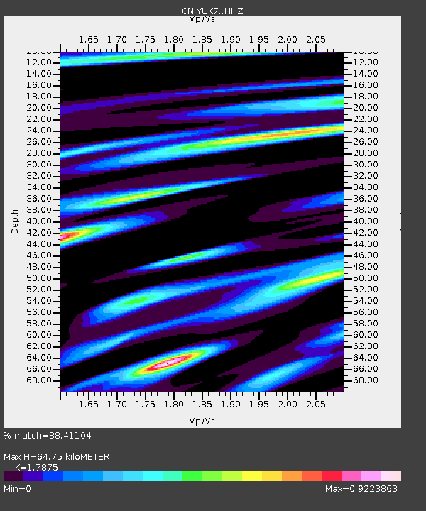
| Estimated Moho Depth: |
64.75 km |
| Estimated Crust Vp/Vs: |
1.79 |
| Assumed Crust Vp: |
6.566 km/s |
| Estimated Crust Vs: |
3.673 km/s |
| Estimated Crust Poisson's Ratio: |
0.27 |
|
| Radial Match: |
88.41104 % |
| Radial Bump: |
400 |
| Transverse Match: |
72.18728 % |
| Transverse Bump: |
400 |
| SOD ConfigId: |
25131211 |
| Insert Time: |
2021-09-22 02:02:24.259 +0000 |
| GWidth: |
2.5 |
| Max Bumps: |
400 |
| Tol: |
0.001 |
|

Signal To Noise
| Channel | StoN | STA | LTA |
| CN:YUK7: :HHZ:20210908T01:56:20.889977Z | 56.8741 | 6.193752E-6 | 1.0890287E-7 |
| CN:YUK7: :HHN:20210908T01:56:20.889977Z | 6.860587 | 1.923846E-6 | 2.8042E-7 |
| CN:YUK7: :HHE:20210908T01:56:20.889977Z | 5.5276947 | 2.4136293E-6 | 4.36643E-7 |
| Arrivals |
| Ps | 8.2 SECOND |
| PpPs | 26 SECOND |
| PsPs/PpSs | 34 SECOND |


