You are here: Home > Network List > GS - US Geological Survey Networks Stations List
> Station PR02 PR02, Guayanilla > Earthquake Result Viewer
PR02 PR02, Guayanilla - Earthquake Result Viewer
| Earthquake location: |
Near Coast Of Guerrero, Mexico |
| Earthquake latitude/longitude: |
17.0/-99.8 |
| Earthquake time(UTC): |
2021/09/08 (251) 01:47:46 GMT |
| Earthquake Depth: |
13 km |
| Earthquake Magnitude: |
7.0 mww |
| Earthquake Catalog/Contributor: |
NEIC PDE/us |
|
| Network: |
GS US Geological Survey Networks |
| Station: |
PR02 PR02, Guayanilla |
| Lat/Lon: |
18.01 N/66.77 W |
| Elevation: |
3.0 m |
|
| Distance: |
31.5 deg |
| Az: |
83.076 deg |
| Baz: |
273.19 deg |
| Ray Param: |
0.07905163 |
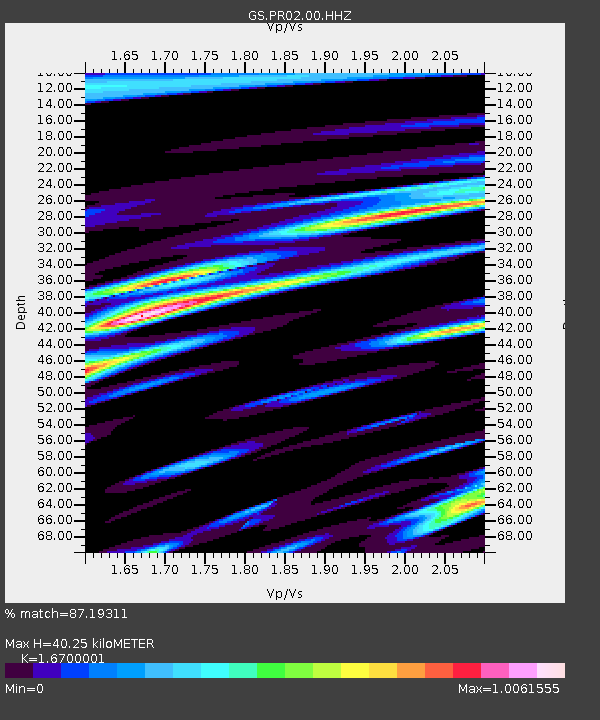
| Estimated Moho Depth: |
40.25 km |
| Estimated Crust Vp/Vs: |
1.67 |
| Assumed Crust Vp: |
5.14 km/s |
| Estimated Crust Vs: |
3.078 km/s |
| Estimated Crust Poisson's Ratio: |
0.22 |
|
| Radial Match: |
87.19311 % |
| Radial Bump: |
400 |
| Transverse Match: |
72.43183 % |
| Transverse Bump: |
400 |
| SOD ConfigId: |
25131211 |
| Insert Time: |
2021-09-22 02:03:59.112 +0000 |
| GWidth: |
2.5 |
| Max Bumps: |
400 |
| Tol: |
0.001 |
|

Signal To Noise
| Channel | StoN | STA | LTA |
| GS:PR02:00:HHZ:20210908T01:53:37.64901Z | 43.54626 | 1.2336776E-5 | 2.8330277E-7 |
| GS:PR02:00:HH1:20210908T01:53:37.64901Z | 4.4962063 | 1.378104E-6 | 3.0650372E-7 |
| GS:PR02:00:HH2:20210908T01:53:37.64901Z | 19.882372 | 8.630568E-6 | 4.3408144E-7 |
| Arrivals |
| Ps | 5.5 SECOND |
| PpPs | 20 SECOND |
| PsPs/PpSs | 25 SECOND |


