You are here: Home > Network List > IU - Global Seismograph Network (GSN - IRIS/USGS) Stations List
> Station MACI Morro de la Arena, Canary Islands > Earthquake Result Viewer
MACI Morro de la Arena, Canary Islands - Earthquake Result Viewer
| Earthquake location: |
Near Coast Of Guerrero, Mexico |
| Earthquake latitude/longitude: |
17.0/-99.8 |
| Earthquake time(UTC): |
2021/09/08 (251) 01:47:46 GMT |
| Earthquake Depth: |
13 km |
| Earthquake Magnitude: |
7.0 mww |
| Earthquake Catalog/Contributor: |
NEIC PDE/us |
|
| Network: |
IU Global Seismograph Network (GSN - IRIS/USGS) |
| Station: |
MACI Morro de la Arena, Canary Islands |
| Lat/Lon: |
28.25 N/16.51 W |
| Elevation: |
1674 m |
|
| Distance: |
76.4 deg |
| Az: |
64.349 deg |
| Baz: |
282.049 deg |
| Ray Param: |
0.051027287 |
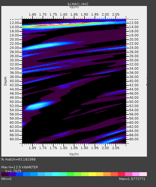
| Estimated Moho Depth: |
12.5 km |
| Estimated Crust Vp/Vs: |
1.78 |
| Assumed Crust Vp: |
4.662 km/s |
| Estimated Crust Vs: |
2.616 km/s |
| Estimated Crust Poisson's Ratio: |
0.27 |
|
| Radial Match: |
93.161896 % |
| Radial Bump: |
374 |
| Transverse Match: |
90.3167 % |
| Transverse Bump: |
347 |
| SOD ConfigId: |
25131211 |
| Insert Time: |
2021-09-22 02:05:00.037 +0000 |
| GWidth: |
2.5 |
| Max Bumps: |
400 |
| Tol: |
0.001 |
|

Signal To Noise
| Channel | StoN | STA | LTA |
| IU:MACI: :HHZ:20210908T01:59:04.560021Z | 18.585255 | 5.79216E-7 | 3.1165357E-8 |
| IU:MACI: :HHN:20210908T01:59:04.560021Z | 1.8376677 | 6.786121E-8 | 3.6927897E-8 |
| IU:MACI: :HHE:20210908T01:59:04.560021Z | 5.7840824 | 2.2375694E-7 | 3.8684952E-8 |
| Arrivals |
| Ps | 2.1 SECOND |
| PpPs | 7.3 SECOND |
| PsPs/PpSs | 9.5 SECOND |


