You are here: Home > Network List > LD - Lamont-Doherty Cooperative Seismographic Network Stations List
> Station FLET Fletcher, VT > Earthquake Result Viewer
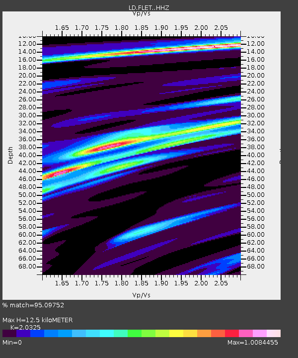
FLET Fletcher, VT - Earthquake Result Viewer
| Earthquake location: |
Near Coast Of Guerrero, Mexico |
| Earthquake latitude/longitude: |
17.0/-99.8 |
| Earthquake time(UTC): |
2021/09/08 (251) 01:47:46 GMT |
| Earthquake Depth: |
13 km |
| Earthquake Magnitude: |
7.0 mww |
| Earthquake Catalog/Contributor: |
NEIC PDE/us |
|
| Network: |
LD Lamont-Doherty Cooperative Seismographic Network |
| Station: |
FLET Fletcher, VT |
| Lat/Lon: |
44.72 N/72.95 W |
| Elevation: |
366 m |
|
| Distance: |
35.7 deg |
| Az: |
33.464 deg |
| Baz: |
227.758 deg |
| Ray Param: |
0.07707308 |
| Estimated Moho Depth: |
12.5 km |
| Estimated Crust Vp/Vs: |
2.03 |
| Assumed Crust Vp: |
6.419 km/s |
| Estimated Crust Vs: |
3.158 km/s |
| Estimated Crust Poisson's Ratio: |
0.34 |
|
| Radial Match: |
95.09752 % |
| Radial Bump: |
250 |
| Transverse Match: |
86.80669 % |
| Transverse Bump: |
400 |
| SOD ConfigId: |
25131211 |
| Insert Time: |
2021-09-22 02:05:21.236 +0000 |
| GWidth: |
2.5 |
| Max Bumps: |
400 |
| Tol: |
0.001 |
|

Signal To Noise
| Channel | StoN | STA | LTA |
| LD:FLET: :HHZ:20210908T01:54:14.240013Z | 149.74066 | 2.0240263E-5 | 1.3516878E-7 |
| LD:FLET: :HHN:20210908T01:54:14.240013Z | 62.990353 | 7.931569E-6 | 1.259172E-7 |
| LD:FLET: :HHE:20210908T01:54:14.240013Z | 83.82902 | 1.1124218E-5 | 1.3270127E-7 |
| Arrivals |
| Ps | 2.1 SECOND |
| PpPs | 5.5 SECOND |
| PsPs/PpSs | 7.7 SECOND |


