You are here: Home > Network List > N4 - Central and EAstern US Network Stations List
> Station K62A Royalston, MA, USA > Earthquake Result Viewer
K62A Royalston, MA, USA - Earthquake Result Viewer
| Earthquake location: |
Near Coast Of Guerrero, Mexico |
| Earthquake latitude/longitude: |
17.0/-99.8 |
| Earthquake time(UTC): |
2021/09/08 (251) 01:47:46 GMT |
| Earthquake Depth: |
13 km |
| Earthquake Magnitude: |
7.0 mww |
| Earthquake Catalog/Contributor: |
NEIC PDE/us |
|
| Network: |
N4 Central and EAstern US Network |
| Station: |
K62A Royalston, MA, USA |
| Lat/Lon: |
42.67 N/72.23 W |
| Elevation: |
289 m |
|
| Distance: |
34.8 deg |
| Az: |
36.756 deg |
| Baz: |
230.942 deg |
| Ray Param: |
0.07757706 |
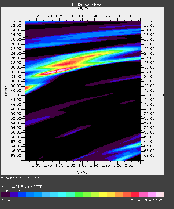
| Estimated Moho Depth: |
31.5 km |
| Estimated Crust Vp/Vs: |
1.74 |
| Assumed Crust Vp: |
6.419 km/s |
| Estimated Crust Vs: |
3.7 km/s |
| Estimated Crust Poisson's Ratio: |
0.25 |
|
| Radial Match: |
96.556854 % |
| Radial Bump: |
222 |
| Transverse Match: |
86.25215 % |
| Transverse Bump: |
400 |
| SOD ConfigId: |
25131211 |
| Insert Time: |
2021-09-22 02:06:18.762 +0000 |
| GWidth: |
2.5 |
| Max Bumps: |
400 |
| Tol: |
0.001 |
|

Signal To Noise
| Channel | StoN | STA | LTA |
| N4:K62A:00:HHZ:20210908T01:54:06.119011Z | 87.8225 | 1.909048E-5 | 2.1737571E-7 |
| N4:K62A:00:HH1:20210908T01:54:06.119011Z | 52.28723 | 9.335928E-6 | 1.7855082E-7 |
| N4:K62A:00:HH2:20210908T01:54:06.119011Z | 90.97166 | 9.701091E-6 | 1.0663861E-7 |
| Arrivals |
| Ps | 3.9 SECOND |
| PpPs | 12 SECOND |
| PsPs/PpSs | 16 SECOND |


