You are here: Home > Network List > NE - New England Seismic Network Stations List
> Station HNH Hanover, NH, USA > Earthquake Result Viewer
HNH Hanover, NH, USA - Earthquake Result Viewer
| Earthquake location: |
Near Coast Of Guerrero, Mexico |
| Earthquake latitude/longitude: |
17.0/-99.8 |
| Earthquake time(UTC): |
2021/09/08 (251) 01:47:46 GMT |
| Earthquake Depth: |
13 km |
| Earthquake Magnitude: |
7.0 mww |
| Earthquake Catalog/Contributor: |
NEIC PDE/us |
|
| Network: |
NE New England Seismic Network |
| Station: |
HNH Hanover, NH, USA |
| Lat/Lon: |
43.71 N/72.29 W |
| Elevation: |
180 m |
|
| Distance: |
35.4 deg |
| Az: |
35.322 deg |
| Baz: |
229.732 deg |
| Ray Param: |
0.077241145 |
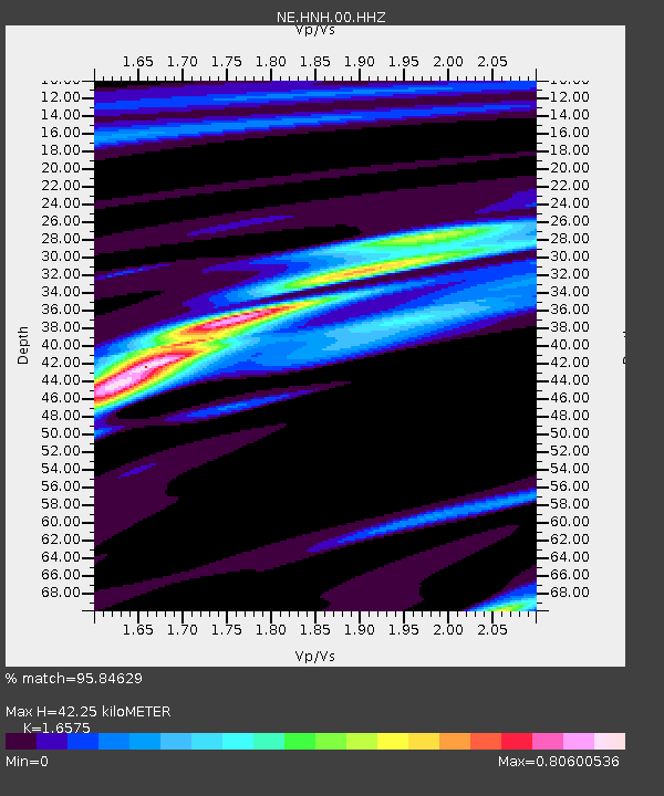
| Estimated Moho Depth: |
42.25 km |
| Estimated Crust Vp/Vs: |
1.66 |
| Assumed Crust Vp: |
6.419 km/s |
| Estimated Crust Vs: |
3.873 km/s |
| Estimated Crust Poisson's Ratio: |
0.21 |
|
| Radial Match: |
95.84629 % |
| Radial Bump: |
225 |
| Transverse Match: |
94.166084 % |
| Transverse Bump: |
390 |
| SOD ConfigId: |
25131211 |
| Insert Time: |
2021-09-22 02:06:43.055 +0000 |
| GWidth: |
2.5 |
| Max Bumps: |
400 |
| Tol: |
0.001 |
|

Signal To Noise
| Channel | StoN | STA | LTA |
| NE:HNH:00:HHZ:20210908T01:54:11.579002Z | 128.71695 | 1.9836376E-5 | 1.5410849E-7 |
| NE:HNH:00:HH1:20210908T01:54:11.579002Z | 83.916016 | 1.1439412E-5 | 1.3631977E-7 |
| NE:HNH:00:HH2:20210908T01:54:11.579002Z | 46.920174 | 6.5759928E-6 | 1.4015278E-7 |
| Arrivals |
| Ps | 4.7 SECOND |
| PpPs | 16 SECOND |
| PsPs/PpSs | 21 SECOND |


