You are here: Home > Network List > PR - Puerto Rico Seismic Network (PRSN) & Puerto Rico Strong Motion Program (PRSMP) Stations List
> Station HUMP HUMP > Earthquake Result Viewer
HUMP HUMP - Earthquake Result Viewer
| Earthquake location: |
Near Coast Of Guerrero, Mexico |
| Earthquake latitude/longitude: |
17.0/-99.8 |
| Earthquake time(UTC): |
2021/09/08 (251) 01:47:46 GMT |
| Earthquake Depth: |
13 km |
| Earthquake Magnitude: |
7.0 mww |
| Earthquake Catalog/Contributor: |
NEIC PDE/us |
|
| Network: |
PR Puerto Rico Seismic Network (PRSN) & Puerto Rico Strong Motion Program (PRSMP) |
| Station: |
HUMP HUMP |
| Lat/Lon: |
18.14 N/65.85 W |
| Elevation: |
80 m |
|
| Distance: |
32.4 deg |
| Az: |
82.741 deg |
| Baz: |
273.19 deg |
| Ray Param: |
0.078696236 |
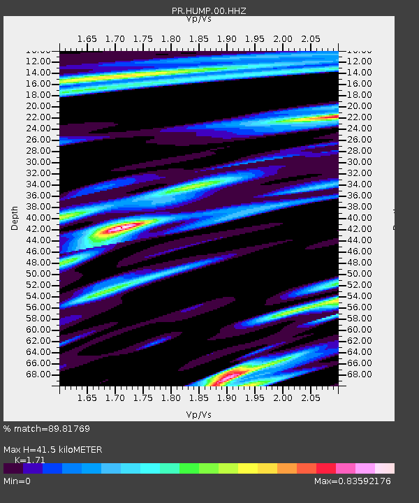
| Estimated Moho Depth: |
41.5 km |
| Estimated Crust Vp/Vs: |
1.71 |
| Assumed Crust Vp: |
5.14 km/s |
| Estimated Crust Vs: |
3.006 km/s |
| Estimated Crust Poisson's Ratio: |
0.24 |
|
| Radial Match: |
89.81769 % |
| Radial Bump: |
289 |
| Transverse Match: |
80.97948 % |
| Transverse Bump: |
400 |
| SOD ConfigId: |
25131211 |
| Insert Time: |
2021-09-22 02:08:43.152 +0000 |
| GWidth: |
2.5 |
| Max Bumps: |
400 |
| Tol: |
0.001 |
|

Signal To Noise
| Channel | StoN | STA | LTA |
| PR:HUMP:00:HHZ:20210908T01:53:45.249992Z | 78.80335 | 1.1046183E-5 | 1.4017404E-7 |
| PR:HUMP:00:HH1:20210908T01:53:45.249992Z | 20.979248 | 3.9693437E-6 | 1.8920332E-7 |
| PR:HUMP:00:HH2:20210908T01:53:45.249992Z | 43.26632 | 7.280952E-6 | 1.6828221E-7 |
| Arrivals |
| Ps | 6.0 SECOND |
| PpPs | 21 SECOND |
| PsPs/PpSs | 27 SECOND |


