You are here: Home > Network List > RV - Regional Alberta Seismic Observatory for Earthquake Studies Network Stations List
> Station REDDA Red Deer Airport, AB > Earthquake Result Viewer
REDDA Red Deer Airport, AB - Earthquake Result Viewer
| Earthquake location: |
Near Coast Of Guerrero, Mexico |
| Earthquake latitude/longitude: |
17.0/-99.8 |
| Earthquake time(UTC): |
2021/09/08 (251) 01:47:46 GMT |
| Earthquake Depth: |
13 km |
| Earthquake Magnitude: |
7.0 mww |
| Earthquake Catalog/Contributor: |
NEIC PDE/us |
|
| Network: |
RV Regional Alberta Seismic Observatory for Earthquake Studies Network |
| Station: |
REDDA Red Deer Airport, AB |
| Lat/Lon: |
52.18 N/113.90 W |
| Elevation: |
892 m |
|
| Distance: |
36.9 deg |
| Az: |
345.51 deg |
| Baz: |
157.113 deg |
| Ray Param: |
0.07645818 |
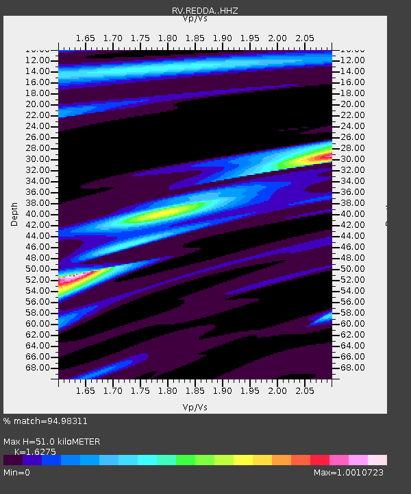
| Estimated Moho Depth: |
51.0 km |
| Estimated Crust Vp/Vs: |
1.63 |
| Assumed Crust Vp: |
6.483 km/s |
| Estimated Crust Vs: |
3.983 km/s |
| Estimated Crust Poisson's Ratio: |
0.20 |
|
| Radial Match: |
94.98311 % |
| Radial Bump: |
210 |
| Transverse Match: |
86.15797 % |
| Transverse Bump: |
377 |
| SOD ConfigId: |
25131211 |
| Insert Time: |
2021-09-22 02:09:00.452 +0000 |
| GWidth: |
2.5 |
| Max Bumps: |
400 |
| Tol: |
0.001 |
|

Signal To Noise
| Channel | StoN | STA | LTA |
| RV:REDDA: :HHZ:20210908T01:54:24.279991Z | 57.340504 | 1.4027252E-5 | 2.446308E-7 |
| RV:REDDA: :HHN:20210908T01:54:24.279991Z | 25.73575 | 6.6955477E-6 | 2.6016522E-7 |
| RV:REDDA: :HHE:20210908T01:54:24.279991Z | 21.35039 | 5.9024383E-6 | 2.7645575E-7 |
| Arrivals |
| Ps | 5.4 SECOND |
| PpPs | 19 SECOND |
| PsPs/PpSs | 24 SECOND |


