You are here: Home > Network List > TD - TransAlta Monitoring Network Stations List
> Station TD007 Z > Earthquake Result Viewer
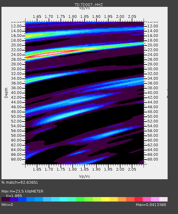
TD007 Z - Earthquake Result Viewer
| Earthquake location: |
Near Coast Of Guerrero, Mexico |
| Earthquake latitude/longitude: |
17.0/-99.8 |
| Earthquake time(UTC): |
2021/09/08 (251) 01:47:46 GMT |
| Earthquake Depth: |
13 km |
| Earthquake Magnitude: |
7.0 mww |
| Earthquake Catalog/Contributor: |
NEIC PDE/us |
|
| Network: |
TD TransAlta Monitoring Network |
| Station: |
TD007 Z |
| Lat/Lon: |
52.91 N/115.62 W |
| Elevation: |
988 m |
|
| Distance: |
38.0 deg |
| Az: |
344.426 deg |
| Baz: |
154.896 deg |
| Ray Param: |
0.07582424 |
| Estimated Moho Depth: |
23.5 km |
| Estimated Crust Vp/Vs: |
1.70 |
| Assumed Crust Vp: |
6.426 km/s |
| Estimated Crust Vs: |
3.791 km/s |
| Estimated Crust Poisson's Ratio: |
0.23 |
|
| Radial Match: |
92.63651 % |
| Radial Bump: |
325 |
| Transverse Match: |
82.03005 % |
| Transverse Bump: |
339 |
| SOD ConfigId: |
25131211 |
| Insert Time: |
2021-09-22 02:09:15.932 +0000 |
| GWidth: |
2.5 |
| Max Bumps: |
400 |
| Tol: |
0.001 |
|

Signal To Noise
| Channel | StoN | STA | LTA |
| TD:TD007: :HHZ:20210908T01:54:33.510002Z | 53.24187 | 8.231393E-6 | 1.5460375E-7 |
| TD:TD007: :HH1:20210908T01:54:33.510002Z | 1.9427286 | 3.4216552E-7 | 1.7612626E-7 |
| TD:TD007: :HH2:20210908T01:54:33.510002Z | 19.573082 | 5.1578154E-6 | 2.6351574E-7 |
| Arrivals |
| Ps | 2.7 SECOND |
| PpPs | 9.1 SECOND |
| PsPs/PpSs | 12 SECOND |


