You are here: Home > Network List > UO - University of Oregon Regional Network Stations List
> Station DING Powers, OR, USA > Earthquake Result Viewer
DING Powers, OR, USA - Earthquake Result Viewer
| Earthquake location: |
Near Coast Of Guerrero, Mexico |
| Earthquake latitude/longitude: |
17.0/-99.8 |
| Earthquake time(UTC): |
2021/09/08 (251) 01:47:46 GMT |
| Earthquake Depth: |
13 km |
| Earthquake Magnitude: |
7.0 mww |
| Earthquake Catalog/Contributor: |
NEIC PDE/us |
|
| Network: |
UO University of Oregon Regional Network |
| Station: |
DING Powers, OR, USA |
| Lat/Lon: |
42.86 N/124.05 W |
| Elevation: |
100 m |
|
| Distance: |
33.1 deg |
| Az: |
326.38 deg |
| Baz: |
133.886 deg |
| Ray Param: |
0.07836893 |
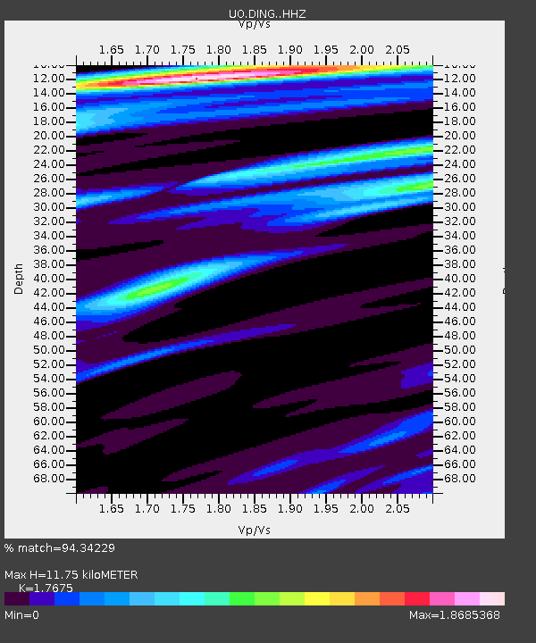
| Estimated Moho Depth: |
11.75 km |
| Estimated Crust Vp/Vs: |
1.77 |
| Assumed Crust Vp: |
6.048 km/s |
| Estimated Crust Vs: |
3.422 km/s |
| Estimated Crust Poisson's Ratio: |
0.26 |
|
| Radial Match: |
94.34229 % |
| Radial Bump: |
276 |
| Transverse Match: |
78.82653 % |
| Transverse Bump: |
400 |
| SOD ConfigId: |
25131211 |
| Insert Time: |
2021-09-22 02:09:37.371 +0000 |
| GWidth: |
2.5 |
| Max Bumps: |
400 |
| Tol: |
0.001 |
|

Signal To Noise
| Channel | StoN | STA | LTA |
| UO:DING: :HHZ:20210908T01:53:51.529991Z | 47.138115 | 9.014522E-6 | 1.9123637E-7 |
| UO:DING: :HHN:20210908T01:53:51.529991Z | 20.478212 | 3.7754362E-6 | 1.8436356E-7 |
| UO:DING: :HHE:20210908T01:53:51.529991Z | 20.543509 | 3.6318693E-6 | 1.7678914E-7 |
| Arrivals |
| Ps | 1.6 SECOND |
| PpPs | 5.0 SECOND |
| PsPs/PpSs | 6.6 SECOND |


