You are here: Home > Network List > UO - University of Oregon Regional Network Stations List
> Station LAIR Myrtle Point, OR, USA > Earthquake Result Viewer
LAIR Myrtle Point, OR, USA - Earthquake Result Viewer
| Earthquake location: |
Near Coast Of Guerrero, Mexico |
| Earthquake latitude/longitude: |
17.0/-99.8 |
| Earthquake time(UTC): |
2021/09/08 (251) 01:47:46 GMT |
| Earthquake Depth: |
13 km |
| Earthquake Magnitude: |
7.0 mww |
| Earthquake Catalog/Contributor: |
NEIC PDE/us |
|
| Network: |
UO University of Oregon Regional Network |
| Station: |
LAIR Myrtle Point, OR, USA |
| Lat/Lon: |
43.16 N/123.93 W |
| Elevation: |
128 m |
|
| Distance: |
33.2 deg |
| Az: |
326.888 deg |
| Baz: |
134.394 deg |
| Ray Param: |
0.07831017 |
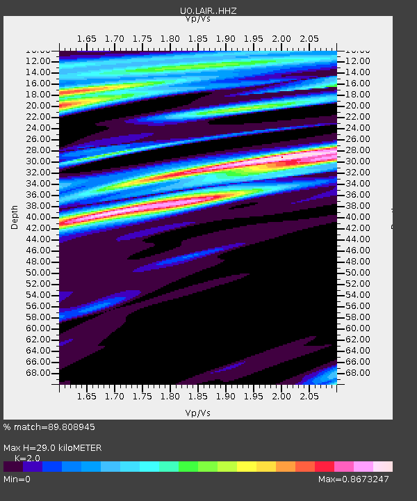
| Estimated Moho Depth: |
29.0 km |
| Estimated Crust Vp/Vs: |
2.00 |
| Assumed Crust Vp: |
6.522 km/s |
| Estimated Crust Vs: |
3.261 km/s |
| Estimated Crust Poisson's Ratio: |
0.33 |
|
| Radial Match: |
89.808945 % |
| Radial Bump: |
301 |
| Transverse Match: |
74.839 % |
| Transverse Bump: |
400 |
| SOD ConfigId: |
25131211 |
| Insert Time: |
2021-09-22 02:09:51.699 +0000 |
| GWidth: |
2.5 |
| Max Bumps: |
400 |
| Tol: |
0.001 |
|

Signal To Noise
| Channel | StoN | STA | LTA |
| UO:LAIR: :HHZ:20210908T01:53:52.787987Z | 31.271618 | 9.536255E-6 | 3.0494922E-7 |
| UO:LAIR: :HHN:20210908T01:53:52.787987Z | 28.644539 | 3.7103316E-6 | 1.2953015E-7 |
| UO:LAIR: :HHE:20210908T01:53:52.787987Z | 19.572092 | 4.1573494E-6 | 2.1241209E-7 |
| Arrivals |
| Ps | 4.8 SECOND |
| PpPs | 12 SECOND |
| PsPs/PpSs | 17 SECOND |


