You are here: Home > Network List > UO - University of Oregon Regional Network Stations List
> Station UCHR Logsden, OR, USA > Earthquake Result Viewer
UCHR Logsden, OR, USA - Earthquake Result Viewer
| Earthquake location: |
Near Coast Of Guerrero, Mexico |
| Earthquake latitude/longitude: |
17.0/-99.8 |
| Earthquake time(UTC): |
2021/09/08 (251) 01:47:46 GMT |
| Earthquake Depth: |
13 km |
| Earthquake Magnitude: |
7.0 mww |
| Earthquake Catalog/Contributor: |
NEIC PDE/us |
|
| Network: |
UO University of Oregon Regional Network |
| Station: |
UCHR Logsden, OR, USA |
| Lat/Lon: |
44.83 N/123.87 W |
| Elevation: |
742 m |
|
| Distance: |
34.4 deg |
| Az: |
329.058 deg |
| Baz: |
136.239 deg |
| Ray Param: |
0.077768534 |
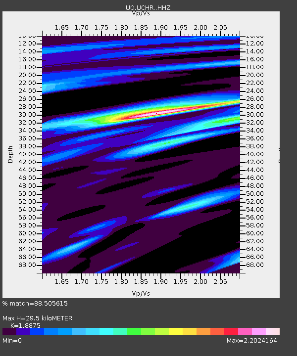
| Estimated Moho Depth: |
29.5 km |
| Estimated Crust Vp/Vs: |
1.89 |
| Assumed Crust Vp: |
6.566 km/s |
| Estimated Crust Vs: |
3.479 km/s |
| Estimated Crust Poisson's Ratio: |
0.30 |
|
| Radial Match: |
88.505615 % |
| Radial Bump: |
400 |
| Transverse Match: |
82.00318 % |
| Transverse Bump: |
400 |
| SOD ConfigId: |
25131211 |
| Insert Time: |
2021-09-22 02:10:17.533 +0000 |
| GWidth: |
2.5 |
| Max Bumps: |
400 |
| Tol: |
0.001 |
|

Signal To Noise
| Channel | StoN | STA | LTA |
| UO:UCHR: :HHZ:20210908T01:54:02.83001Z | 26.48529 | 9.562914E-6 | 3.610651E-7 |
| UO:UCHR: :HHN:20210908T01:54:02.83001Z | 15.742016 | 5.0528383E-6 | 3.2097785E-7 |
| UO:UCHR: :HHE:20210908T01:54:02.83001Z | 12.234473 | 3.7764796E-6 | 3.086753E-7 |
| Arrivals |
| Ps | 4.3 SECOND |
| PpPs | 12 SECOND |
| PsPs/PpSs | 16 SECOND |


