You are here: Home > Network List > US - United States National Seismic Network Stations List
> Station DGMT Dagmar, Montana, USA > Earthquake Result Viewer
DGMT Dagmar, Montana, USA - Earthquake Result Viewer
| Earthquake location: |
Near Coast Of Guerrero, Mexico |
| Earthquake latitude/longitude: |
17.0/-99.8 |
| Earthquake time(UTC): |
2021/09/08 (251) 01:47:46 GMT |
| Earthquake Depth: |
13 km |
| Earthquake Magnitude: |
7.0 mww |
| Earthquake Catalog/Contributor: |
NEIC PDE/us |
|
| Network: |
US United States National Seismic Network |
| Station: |
DGMT Dagmar, Montana, USA |
| Lat/Lon: |
48.47 N/104.20 W |
| Elevation: |
0.0 m |
|
| Distance: |
31.6 deg |
| Az: |
354.405 deg |
| Baz: |
171.94 deg |
| Ray Param: |
0.078993425 |
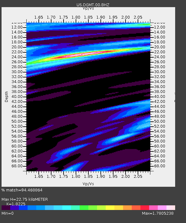
| Estimated Moho Depth: |
22.75 km |
| Estimated Crust Vp/Vs: |
1.82 |
| Assumed Crust Vp: |
6.438 km/s |
| Estimated Crust Vs: |
3.532 km/s |
| Estimated Crust Poisson's Ratio: |
0.28 |
|
| Radial Match: |
94.468864 % |
| Radial Bump: |
264 |
| Transverse Match: |
89.932655 % |
| Transverse Bump: |
280 |
| SOD ConfigId: |
25131211 |
| Insert Time: |
2021-09-22 02:10:33.890 +0000 |
| GWidth: |
2.5 |
| Max Bumps: |
400 |
| Tol: |
0.001 |
|
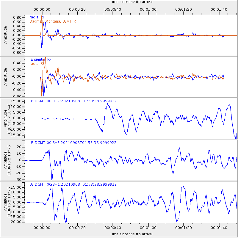
Signal To Noise
| Channel | StoN | STA | LTA |
| US:DGMT:00:BHZ:20210908T01:53:38.999992Z | 71.07018 | 9.174911E-6 | 1.2909648E-7 |
| US:DGMT:00:BH1:20210908T01:53:38.999992Z | 28.653755 | 4.5025554E-6 | 1.5713667E-7 |
| US:DGMT:00:BH2:20210908T01:53:38.999992Z | 29.430809 | 6.0872035E-6 | 2.0683099E-7 |
| Arrivals |
| Ps | 3.1 SECOND |
| PpPs | 9.2 SECOND |
| PsPs/PpSs | 12 SECOND |


