You are here: Home > Network List > US - United States National Seismic Network Stations List
> Station LONY Lake Ozonia, New York, USA > Earthquake Result Viewer
LONY Lake Ozonia, New York, USA - Earthquake Result Viewer
| Earthquake location: |
Near Coast Of Guerrero, Mexico |
| Earthquake latitude/longitude: |
17.0/-99.8 |
| Earthquake time(UTC): |
2021/09/08 (251) 01:47:46 GMT |
| Earthquake Depth: |
13 km |
| Earthquake Magnitude: |
7.0 mww |
| Earthquake Catalog/Contributor: |
NEIC PDE/us |
|
| Network: |
US United States National Seismic Network |
| Station: |
LONY Lake Ozonia, New York, USA |
| Lat/Lon: |
44.62 N/74.58 W |
| Elevation: |
440 m |
|
| Distance: |
34.8 deg |
| Az: |
32.21 deg |
| Baz: |
225.591 deg |
| Ray Param: |
0.07756251 |
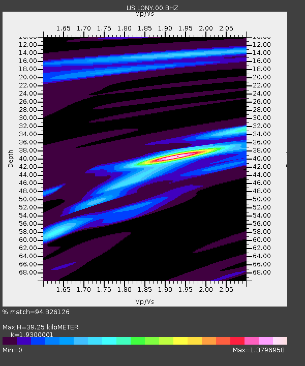
| Estimated Moho Depth: |
39.25 km |
| Estimated Crust Vp/Vs: |
1.93 |
| Assumed Crust Vp: |
6.419 km/s |
| Estimated Crust Vs: |
3.326 km/s |
| Estimated Crust Poisson's Ratio: |
0.32 |
|
| Radial Match: |
94.826126 % |
| Radial Bump: |
271 |
| Transverse Match: |
93.84916 % |
| Transverse Bump: |
277 |
| SOD ConfigId: |
25131211 |
| Insert Time: |
2021-09-22 02:10:43.607 +0000 |
| GWidth: |
2.5 |
| Max Bumps: |
400 |
| Tol: |
0.001 |
|
Signal To Noise
| Channel | StoN | STA | LTA |
| US:LONY:00:BHZ:20210908T01:54:06.374992Z | 157.24678 | 1.986397E-5 | 1.2632353E-7 |
| US:LONY:00:BH1:20210908T01:54:06.374992Z | 143.74084 | 1.1411012E-5 | 7.938601E-8 |
| US:LONY:00:BH2:20210908T01:54:06.374992Z | 61.880222 | 6.002763E-6 | 9.700616E-8 |
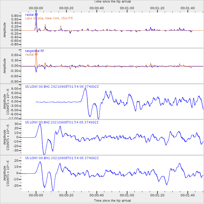
| Arrivals |
| Ps | 6.1 SECOND |
| PpPs | 17 SECOND |
| PsPs/PpSs | 23 SECOND |


