You are here: Home > Network List > US - United States National Seismic Network Stations List
> Station WRAK Wrangell Island, Southeastern Alaska, Alaska, USA > Earthquake Result Viewer
WRAK Wrangell Island, Southeastern Alaska, Alaska, USA - Earthquake Result Viewer

| Earthquake location: |
Near Coast Of Guerrero, Mexico |
| Earthquake latitude/longitude: |
17.0/-99.8 |
| Earthquake time(UTC): |
2021/09/08 (251) 01:47:46 GMT |
| Earthquake Depth: |
13 km |
| Earthquake Magnitude: |
7.0 mww |
| Earthquake Catalog/Contributor: |
NEIC PDE/us |
|
| Network: |
US United States National Seismic Network |
| Station: |
WRAK Wrangell Island, Southeastern Alaska, Alaska, USA |
| Lat/Lon: |
56.42 N/132.35 W |
| Elevation: |
81 m |
|
| Distance: |
46.4 deg |
| Az: |
335.624 deg |
| Baz: |
134.696 deg |
| Ray Param: |
0.07064958 |
| Estimated Moho Depth: |
32.75 km |
| Estimated Crust Vp/Vs: |
1.60 |
| Assumed Crust Vp: |
6.597 km/s |
| Estimated Crust Vs: |
4.123 km/s |
| Estimated Crust Poisson's Ratio: |
0.18 |
|
| Radial Match: |
94.25709 % |
| Radial Bump: |
317 |
| Transverse Match: |
72.198006 % |
| Transverse Bump: |
400 |
| SOD ConfigId: |
25131211 |
| Insert Time: |
2021-09-22 02:10:50.267 +0000 |
| GWidth: |
2.5 |
| Max Bumps: |
400 |
| Tol: |
0.001 |
|
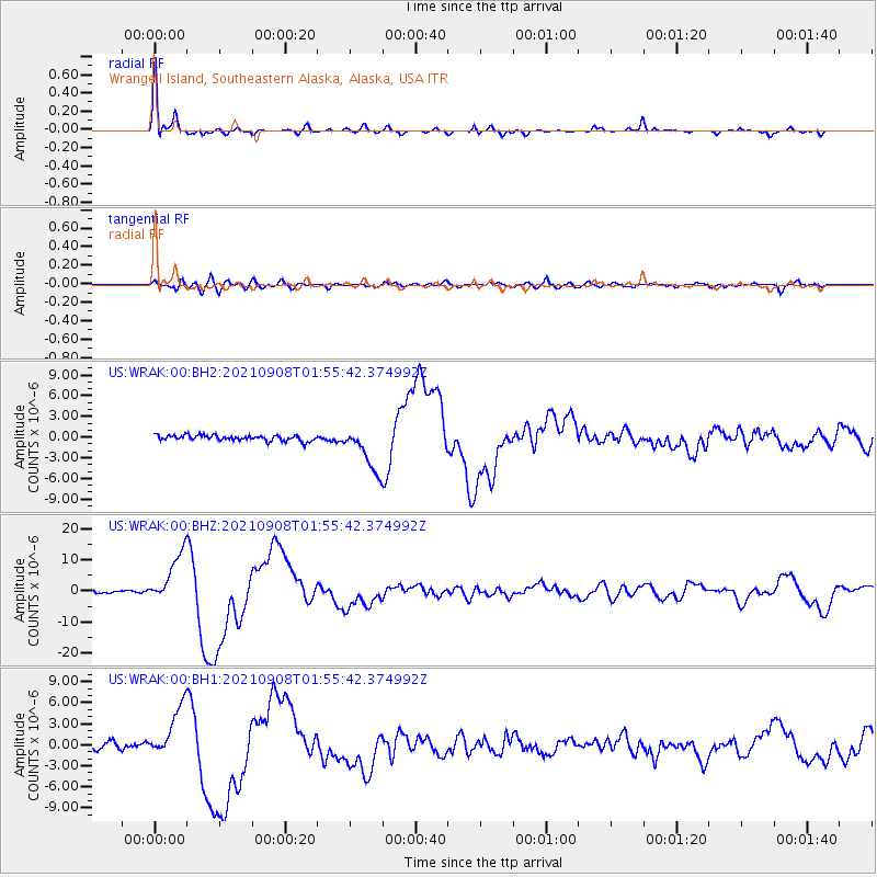
Signal To Noise
| Channel | StoN | STA | LTA |
| US:WRAK:00:BHZ:20210908T01:55:42.374992Z | 14.625988 | 8.0896E-6 | 5.5309766E-7 |
| US:WRAK:00:BH1:20210908T01:55:42.374992Z | 7.508512 | 3.7285674E-6 | 4.9657876E-7 |
| US:WRAK:00:BH2:20210908T01:55:42.374992Z | 8.086057 | 3.287024E-6 | 4.0650517E-7 |
| Arrivals |
| Ps | 3.2 SECOND |
| PpPs | 12 SECOND |
| PsPs/PpSs | 15 SECOND |


