You are here: Home > Network List > UW - Pacific Northwest Regional Seismic Network Stations List
> Station BLOW Detroit Lake, OR, USA > Earthquake Result Viewer
BLOW Detroit Lake, OR, USA - Earthquake Result Viewer
| Earthquake location: |
Near Coast Of Guerrero, Mexico |
| Earthquake latitude/longitude: |
17.0/-99.8 |
| Earthquake time(UTC): |
2021/09/08 (251) 01:47:46 GMT |
| Earthquake Depth: |
13 km |
| Earthquake Magnitude: |
7.0 mww |
| Earthquake Catalog/Contributor: |
NEIC PDE/us |
|
| Network: |
UW Pacific Northwest Regional Seismic Network |
| Station: |
BLOW Detroit Lake, OR, USA |
| Lat/Lon: |
44.68 N/122.19 W |
| Elevation: |
652 m |
|
| Distance: |
33.5 deg |
| Az: |
330.459 deg |
| Baz: |
138.584 deg |
| Ray Param: |
0.07820955 |
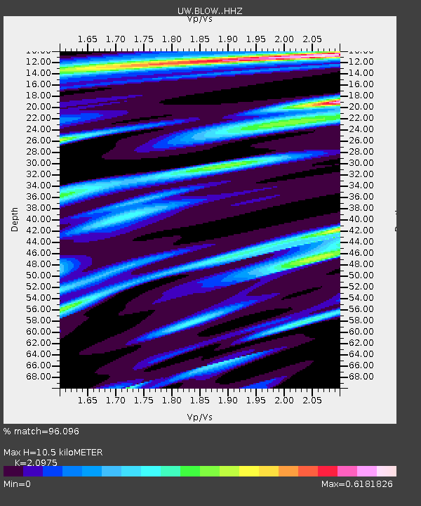
| Estimated Moho Depth: |
10.5 km |
| Estimated Crust Vp/Vs: |
2.10 |
| Assumed Crust Vp: |
6.566 km/s |
| Estimated Crust Vs: |
3.13 km/s |
| Estimated Crust Poisson's Ratio: |
0.35 |
|
| Radial Match: |
96.096 % |
| Radial Bump: |
389 |
| Transverse Match: |
71.54329 % |
| Transverse Bump: |
400 |
| SOD ConfigId: |
25131211 |
| Insert Time: |
2021-09-22 02:10:59.038 +0000 |
| GWidth: |
2.5 |
| Max Bumps: |
400 |
| Tol: |
0.001 |
|
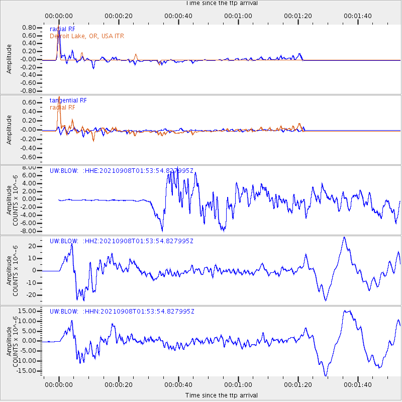
Signal To Noise
| Channel | StoN | STA | LTA |
| UW:BLOW: :HHZ:20210908T01:53:54.827995Z | 91.00547 | 1.0678114E-5 | 1.17334864E-7 |
| UW:BLOW: :HHN:20210908T01:53:54.827995Z | 89.7218 | 4.9480213E-6 | 5.5148483E-8 |
| UW:BLOW: :HHE:20210908T01:53:54.827995Z | 51.23774 | 3.6021263E-6 | 7.0302214E-8 |
| Arrivals |
| Ps | 1.9 SECOND |
| PpPs | 4.6 SECOND |
| PsPs/PpSs | 6.5 SECOND |


