You are here: Home > Network List > UW - Pacific Northwest Regional Seismic Network Stations List
> Station DOTY Weyerhaeuser Tree Farm, Grays Harbor County, WA, USA > Earthquake Result Viewer
DOTY Weyerhaeuser Tree Farm, Grays Harbor County, WA, USA - Earthquake Result Viewer
| Earthquake location: |
Near Coast Of Guerrero, Mexico |
| Earthquake latitude/longitude: |
17.0/-99.8 |
| Earthquake time(UTC): |
2021/09/08 (251) 01:47:46 GMT |
| Earthquake Depth: |
13 km |
| Earthquake Magnitude: |
7.0 mww |
| Earthquake Catalog/Contributor: |
NEIC PDE/us |
|
| Network: |
UW Pacific Northwest Regional Seismic Network |
| Station: |
DOTY Weyerhaeuser Tree Farm, Grays Harbor County, WA, USA |
| Lat/Lon: |
46.70 N/123.37 W |
| Elevation: |
430 m |
|
| Distance: |
35.5 deg |
| Az: |
331.715 deg |
| Baz: |
138.776 deg |
| Ray Param: |
0.0771738 |
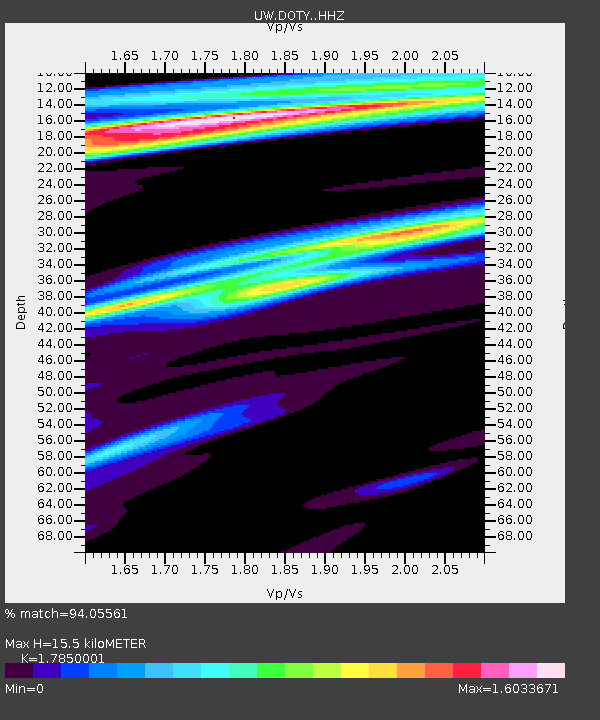
| Estimated Moho Depth: |
15.5 km |
| Estimated Crust Vp/Vs: |
1.79 |
| Assumed Crust Vp: |
6.566 km/s |
| Estimated Crust Vs: |
3.679 km/s |
| Estimated Crust Poisson's Ratio: |
0.27 |
|
| Radial Match: |
94.05561 % |
| Radial Bump: |
331 |
| Transverse Match: |
65.02992 % |
| Transverse Bump: |
400 |
| SOD ConfigId: |
25131211 |
| Insert Time: |
2021-09-22 02:11:19.611 +0000 |
| GWidth: |
2.5 |
| Max Bumps: |
400 |
| Tol: |
0.001 |
|

Signal To Noise
| Channel | StoN | STA | LTA |
| UW:DOTY: :HHZ:20210908T01:54:12.659996Z | 88.19765 | 1.0478566E-5 | 1.1880777E-7 |
| UW:DOTY: :HHN:20210908T01:54:12.659996Z | 31.814783 | 4.394336E-6 | 1.3812246E-7 |
| UW:DOTY: :HHE:20210908T01:54:12.659996Z | 30.696545 | 4.7348976E-6 | 1.5424855E-7 |
| Arrivals |
| Ps | 2.0 SECOND |
| PpPs | 6.1 SECOND |
| PsPs/PpSs | 8.1 SECOND |


