You are here: Home > Network List > UW - Pacific Northwest Regional Seismic Network Stations List
> Station LCCR Clarks, OR, USA > Earthquake Result Viewer
LCCR Clarks, OR, USA - Earthquake Result Viewer
| Earthquake location: |
Near Coast Of Guerrero, Mexico |
| Earthquake latitude/longitude: |
17.0/-99.8 |
| Earthquake time(UTC): |
2021/09/08 (251) 01:47:46 GMT |
| Earthquake Depth: |
13 km |
| Earthquake Magnitude: |
7.0 mww |
| Earthquake Catalog/Contributor: |
NEIC PDE/us |
|
| Network: |
UW Pacific Northwest Regional Seismic Network |
| Station: |
LCCR Clarks, OR, USA |
| Lat/Lon: |
45.21 N/122.48 W |
| Elevation: |
271 m |
|
| Distance: |
34.0 deg |
| Az: |
330.8 deg |
| Baz: |
138.662 deg |
| Ray Param: |
0.07796186 |
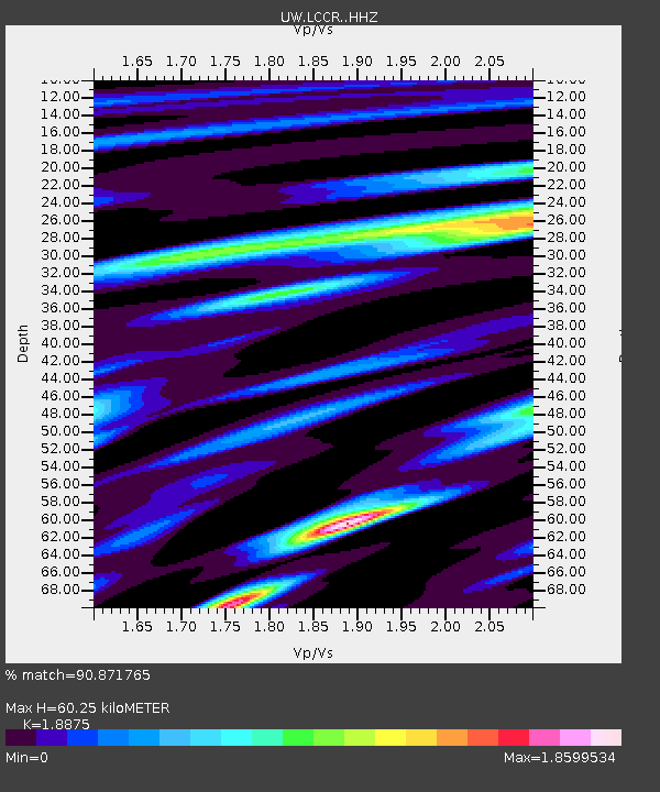
| Estimated Moho Depth: |
60.25 km |
| Estimated Crust Vp/Vs: |
1.89 |
| Assumed Crust Vp: |
6.566 km/s |
| Estimated Crust Vs: |
3.479 km/s |
| Estimated Crust Poisson's Ratio: |
0.30 |
|
| Radial Match: |
90.871765 % |
| Radial Bump: |
400 |
| Transverse Match: |
58.50018 % |
| Transverse Bump: |
400 |
| SOD ConfigId: |
25131211 |
| Insert Time: |
2021-09-22 02:11:46.208 +0000 |
| GWidth: |
2.5 |
| Max Bumps: |
400 |
| Tol: |
0.001 |
|

Signal To Noise
| Channel | StoN | STA | LTA |
| UW:LCCR: :HHZ:20210908T01:53:59.417992Z | 65.02724 | 1.1075992E-5 | 1.7032852E-7 |
| UW:LCCR: :HHN:20210908T01:53:59.417992Z | 27.85686 | 5.2936225E-6 | 1.9002941E-7 |
| UW:LCCR: :HHE:20210908T01:53:59.417992Z | 30.374119 | 4.5704273E-6 | 1.5047111E-7 |
| Arrivals |
| Ps | 8.8 SECOND |
| PpPs | 25 SECOND |
| PsPs/PpSs | 33 SECOND |


