You are here: Home > Network List > UW - Pacific Northwest Regional Seismic Network Stations List
> Station LON Longmire CREST broad-band > Earthquake Result Viewer
LON Longmire CREST broad-band - Earthquake Result Viewer
| Earthquake location: |
Near Coast Of Guerrero, Mexico |
| Earthquake latitude/longitude: |
17.0/-99.8 |
| Earthquake time(UTC): |
2021/09/08 (251) 01:47:46 GMT |
| Earthquake Depth: |
13 km |
| Earthquake Magnitude: |
7.0 mww |
| Earthquake Catalog/Contributor: |
NEIC PDE/us |
|
| Network: |
UW Pacific Northwest Regional Seismic Network |
| Station: |
LON Longmire CREST broad-band |
| Lat/Lon: |
46.75 N/121.81 W |
| Elevation: |
853 m |
|
| Distance: |
34.9 deg |
| Az: |
333.192 deg |
| Baz: |
141.114 deg |
| Ray Param: |
0.077522255 |
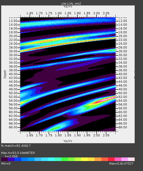
| Estimated Moho Depth: |
53.0 km |
| Estimated Crust Vp/Vs: |
2.06 |
| Assumed Crust Vp: |
6.597 km/s |
| Estimated Crust Vs: |
3.21 km/s |
| Estimated Crust Poisson's Ratio: |
0.34 |
|
| Radial Match: |
92.40617 % |
| Radial Bump: |
332 |
| Transverse Match: |
82.408005 % |
| Transverse Bump: |
400 |
| SOD ConfigId: |
25131211 |
| Insert Time: |
2021-09-22 02:11:51.675 +0000 |
| GWidth: |
2.5 |
| Max Bumps: |
400 |
| Tol: |
0.001 |
|
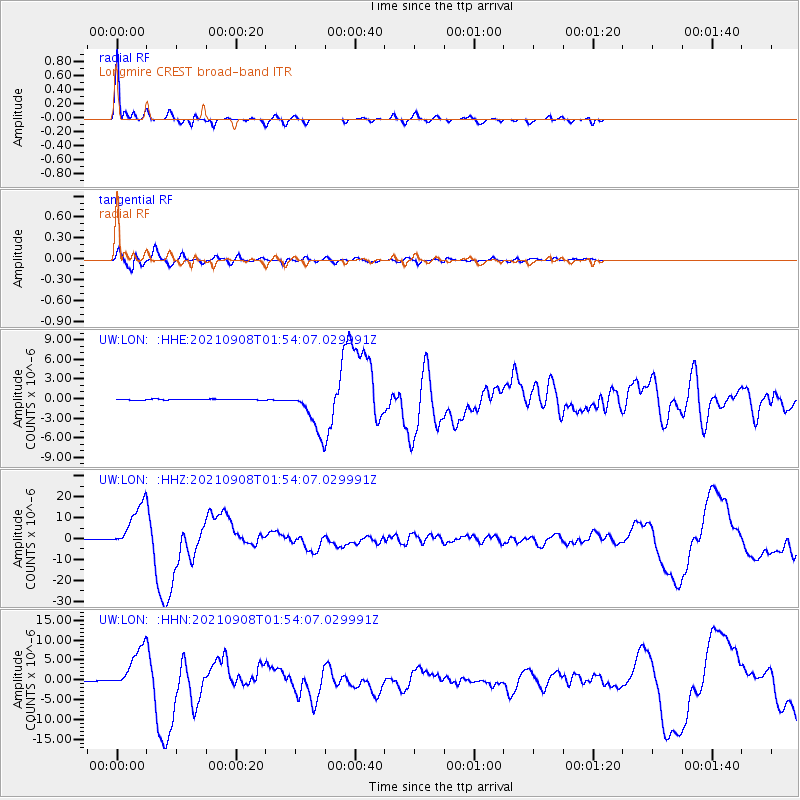
Signal To Noise
| Channel | StoN | STA | LTA |
| UW:LON: :HHZ:20210908T01:54:07.029991Z | 104.99125 | 1.07120795E-5 | 1.0202831E-7 |
| UW:LON: :HHN:20210908T01:54:07.029991Z | 77.24154 | 5.3268272E-6 | 6.896324E-8 |
| UW:LON: :HHE:20210908T01:54:07.029991Z | 47.58881 | 3.288087E-6 | 6.90937E-8 |
| Arrivals |
| Ps | 9.1 SECOND |
| PpPs | 23 SECOND |
| PsPs/PpSs | 32 SECOND |


