You are here: Home > Network List > UW - Pacific Northwest Regional Seismic Network Stations List
> Station LTY Liberty (broad-band) > Earthquake Result Viewer
LTY Liberty (broad-band) - Earthquake Result Viewer
| Earthquake location: |
Near Coast Of Guerrero, Mexico |
| Earthquake latitude/longitude: |
17.0/-99.8 |
| Earthquake time(UTC): |
2021/09/08 (251) 01:47:46 GMT |
| Earthquake Depth: |
13 km |
| Earthquake Magnitude: |
7.0 mww |
| Earthquake Catalog/Contributor: |
NEIC PDE/us |
|
| Network: |
UW Pacific Northwest Regional Seismic Network |
| Station: |
LTY Liberty (broad-band) |
| Lat/Lon: |
47.26 N/120.66 W |
| Elevation: |
970 m |
|
| Distance: |
34.8 deg |
| Az: |
334.818 deg |
| Baz: |
143.284 deg |
| Ray Param: |
0.07756419 |
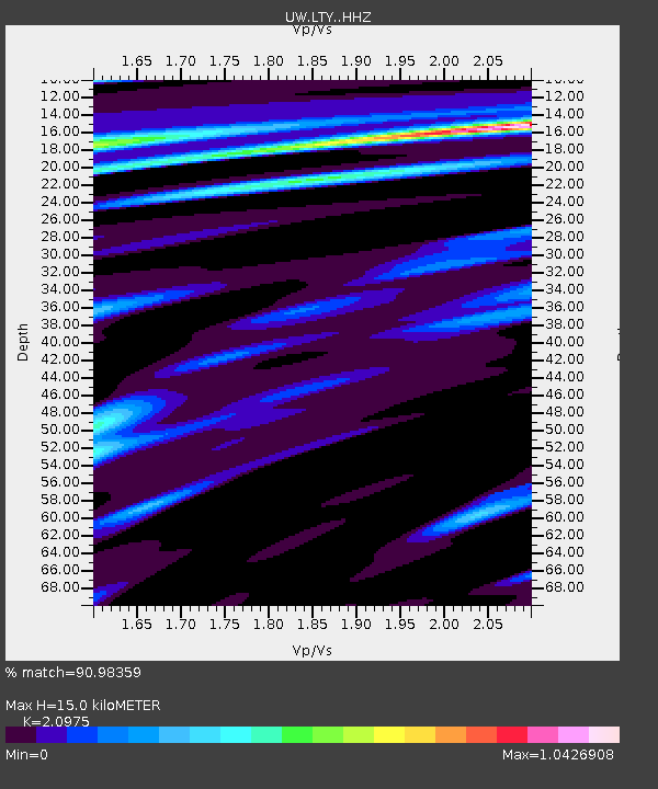
| Estimated Moho Depth: |
15.0 km |
| Estimated Crust Vp/Vs: |
2.10 |
| Assumed Crust Vp: |
6.597 km/s |
| Estimated Crust Vs: |
3.145 km/s |
| Estimated Crust Poisson's Ratio: |
0.35 |
|
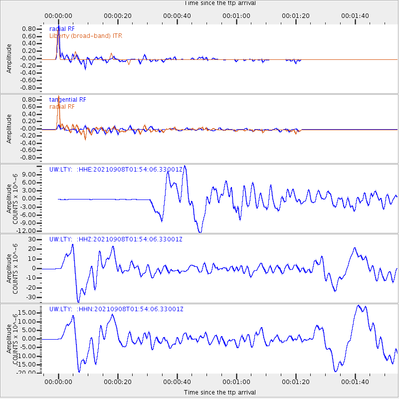
| Radial Match: |
90.98359 % |
| Radial Bump: |
239 |
| Transverse Match: |
83.35237 % |
| Transverse Bump: |
400 |
| SOD ConfigId: |
25131211 |
| Insert Time: |
2021-09-22 02:11:54.374 +0000 |
| GWidth: |
2.5 |
| Max Bumps: |
400 |
| Tol: |
0.001 |
|
Signal To Noise
| Channel | StoN | STA | LTA |
| UW:LTY: :HHZ:20210908T01:54:06.33001Z | 109.63678 | 1.1883919E-5 | 1.0839354E-7 |
| UW:LTY: :HHN:20210908T01:54:06.33001Z | 101.72556 | 6.43445E-6 | 6.3253026E-8 |
| UW:LTY: :HHE:20210908T01:54:06.33001Z | 60.095993 | 3.648984E-6 | 6.071926E-8 |
| Arrivals |
| Ps | 2.7 SECOND |
| PpPs | 6.6 SECOND |
| PsPs/PpSs | 9.2 SECOND |


