You are here: Home > Network List > UW - Pacific Northwest Regional Seismic Network Stations List
> Station RATT Rattlesnake Lake, King County, WA > Earthquake Result Viewer
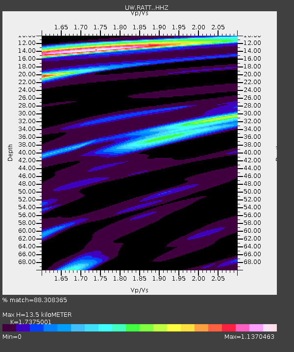
RATT Rattlesnake Lake, King County, WA - Earthquake Result Viewer
| Earthquake location: |
Near Coast Of Guerrero, Mexico |
| Earthquake latitude/longitude: |
17.0/-99.8 |
| Earthquake time(UTC): |
2021/09/08 (251) 01:47:46 GMT |
| Earthquake Depth: |
13 km |
| Earthquake Magnitude: |
7.0 mww |
| Earthquake Catalog/Contributor: |
NEIC PDE/us |
|
| Network: |
UW Pacific Northwest Regional Seismic Network |
| Station: |
RATT Rattlesnake Lake, King County, WA |
| Lat/Lon: |
47.43 N/121.80 W |
| Elevation: |
442 m |
|
| Distance: |
35.4 deg |
| Az: |
333.93 deg |
| Baz: |
141.723 deg |
| Ray Param: |
0.07724303 |
| Estimated Moho Depth: |
13.5 km |
| Estimated Crust Vp/Vs: |
1.74 |
| Assumed Crust Vp: |
6.597 km/s |
| Estimated Crust Vs: |
3.797 km/s |
| Estimated Crust Poisson's Ratio: |
0.25 |
|
| Radial Match: |
88.308365 % |
| Radial Bump: |
385 |
| Transverse Match: |
82.64677 % |
| Transverse Bump: |
400 |
| SOD ConfigId: |
25131211 |
| Insert Time: |
2021-09-22 02:12:20.483 +0000 |
| GWidth: |
2.5 |
| Max Bumps: |
400 |
| Tol: |
0.001 |
|

Signal To Noise
| Channel | StoN | STA | LTA |
| UW:RATT: :HHZ:20210908T01:54:11.540001Z | 126.88933 | 1.1728836E-5 | 9.243359E-8 |
| UW:RATT: :HHN:20210908T01:54:11.540001Z | 58.038486 | 3.5240355E-6 | 6.071894E-8 |
| UW:RATT: :HHE:20210908T01:54:11.540001Z | 37.304996 | 5.8008523E-6 | 1.55498E-7 |
| Arrivals |
| Ps | 1.6 SECOND |
| PpPs | 5.2 SECOND |
| PsPs/PpSs | 6.8 SECOND |


