You are here: Home > Network List > UW - Pacific Northwest Regional Seismic Network Stations List
> Station SSO2 House Mountain, Oregon, USA > Earthquake Result Viewer
SSO2 House Mountain, Oregon, USA - Earthquake Result Viewer
| Earthquake location: |
Near Coast Of Guerrero, Mexico |
| Earthquake latitude/longitude: |
17.0/-99.8 |
| Earthquake time(UTC): |
2021/09/08 (251) 01:47:46 GMT |
| Earthquake Depth: |
13 km |
| Earthquake Magnitude: |
7.0 mww |
| Earthquake Catalog/Contributor: |
NEIC PDE/us |
|
| Network: |
UW Pacific Northwest Regional Seismic Network |
| Station: |
SSO2 House Mountain, Oregon, USA |
| Lat/Lon: |
44.84 N/122.48 W |
| Elevation: |
1202 m |
|
| Distance: |
33.7 deg |
| Az: |
330.361 deg |
| Baz: |
138.294 deg |
| Ray Param: |
0.07809111 |
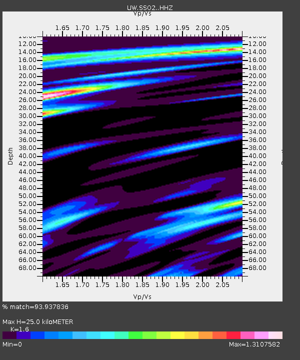
| Estimated Moho Depth: |
25.0 km |
| Estimated Crust Vp/Vs: |
1.60 |
| Assumed Crust Vp: |
6.566 km/s |
| Estimated Crust Vs: |
4.104 km/s |
| Estimated Crust Poisson's Ratio: |
0.18 |
|
| Radial Match: |
93.937836 % |
| Radial Bump: |
400 |
| Transverse Match: |
77.75979 % |
| Transverse Bump: |
400 |
| SOD ConfigId: |
25131211 |
| Insert Time: |
2021-09-22 02:12:37.681 +0000 |
| GWidth: |
2.5 |
| Max Bumps: |
400 |
| Tol: |
0.001 |
|

Signal To Noise
| Channel | StoN | STA | LTA |
| UW:SSO2: :HHZ:20210908T01:53:57.070Z | 92.223694 | 1.05989175E-5 | 1.1492618E-7 |
| UW:SSO2: :HHN:20210908T01:53:57.070Z | 37.476105 | 5.7575107E-6 | 1.536315E-7 |
| UW:SSO2: :HHE:20210908T01:53:57.070Z | 34.695248 | 4.6311497E-6 | 1.334808E-7 |
| Arrivals |
| Ps | 2.5 SECOND |
| PpPs | 9.0 SECOND |
| PsPs/PpSs | 12 SECOND |


