You are here: Home > Network List > UW - Pacific Northwest Regional Seismic Network Stations List
> Station TWISP Winthrop, WA, USA > Earthquake Result Viewer
TWISP Winthrop, WA, USA - Earthquake Result Viewer
| Earthquake location: |
Near Coast Of Guerrero, Mexico |
| Earthquake latitude/longitude: |
17.0/-99.8 |
| Earthquake time(UTC): |
2021/09/08 (251) 01:47:46 GMT |
| Earthquake Depth: |
13 km |
| Earthquake Magnitude: |
7.0 mww |
| Earthquake Catalog/Contributor: |
NEIC PDE/us |
|
| Network: |
UW Pacific Northwest Regional Seismic Network |
| Station: |
TWISP Winthrop, WA, USA |
| Lat/Lon: |
48.46 N/120.12 W |
| Elevation: |
756 m |
|
| Distance: |
35.5 deg |
| Az: |
336.56 deg |
| Baz: |
145.111 deg |
| Ray Param: |
0.07715901 |
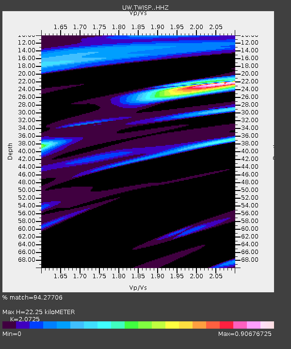
| Estimated Moho Depth: |
22.25 km |
| Estimated Crust Vp/Vs: |
2.07 |
| Assumed Crust Vp: |
6.566 km/s |
| Estimated Crust Vs: |
3.168 km/s |
| Estimated Crust Poisson's Ratio: |
0.35 |
|
| Radial Match: |
94.27706 % |
| Radial Bump: |
343 |
| Transverse Match: |
72.22081 % |
| Transverse Bump: |
400 |
| SOD ConfigId: |
25131211 |
| Insert Time: |
2021-09-22 02:12:42.939 +0000 |
| GWidth: |
2.5 |
| Max Bumps: |
400 |
| Tol: |
0.001 |
|

Signal To Noise
| Channel | StoN | STA | LTA |
| UW:TWISP: :HHZ:20210908T01:54:12.899986Z | 97.99925 | 1.11607515E-5 | 1.13886095E-7 |
| UW:TWISP: :HHN:20210908T01:54:12.899986Z | 46.71351 | 6.006414E-6 | 1.285798E-7 |
| UW:TWISP: :HHE:20210908T01:54:12.899986Z | 37.28147 | 4.5578645E-6 | 1.2225549E-7 |
| Arrivals |
| Ps | 3.9 SECOND |
| PpPs | 9.7 SECOND |
| PsPs/PpSs | 14 SECOND |


