You are here: Home > Network List > UW - Pacific Northwest Regional Seismic Network Stations List
> Station WAT2 Waterville, WA, USA > Earthquake Result Viewer
WAT2 Waterville, WA, USA - Earthquake Result Viewer
| Earthquake location: |
Near Coast Of Guerrero, Mexico |
| Earthquake latitude/longitude: |
17.0/-99.8 |
| Earthquake time(UTC): |
2021/09/08 (251) 01:47:46 GMT |
| Earthquake Depth: |
13 km |
| Earthquake Magnitude: |
7.0 mww |
| Earthquake Catalog/Contributor: |
NEIC PDE/us |
|
| Network: |
UW Pacific Northwest Regional Seismic Network |
| Station: |
WAT2 Waterville, WA, USA |
| Lat/Lon: |
47.62 N/120.11 W |
| Elevation: |
875 m |
|
| Distance: |
34.9 deg |
| Az: |
335.723 deg |
| Baz: |
144.431 deg |
| Ray Param: |
0.07752579 |
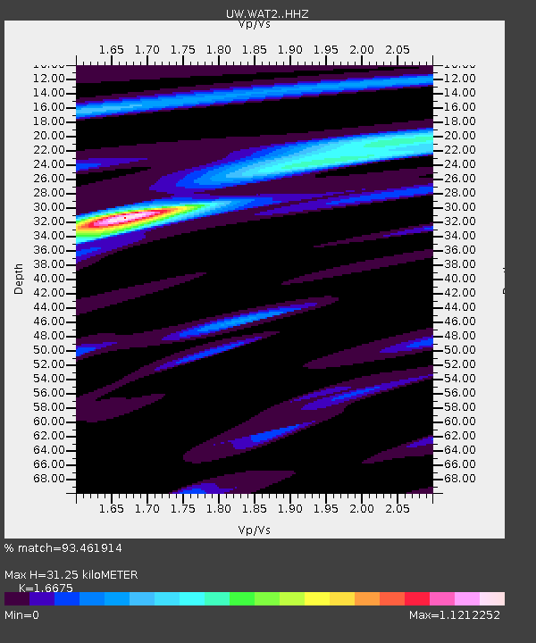
| Estimated Moho Depth: |
31.25 km |
| Estimated Crust Vp/Vs: |
1.67 |
| Assumed Crust Vp: |
6.597 km/s |
| Estimated Crust Vs: |
3.957 km/s |
| Estimated Crust Poisson's Ratio: |
0.22 |
|
| Radial Match: |
93.461914 % |
| Radial Bump: |
363 |
| Transverse Match: |
76.031075 % |
| Transverse Bump: |
400 |
| SOD ConfigId: |
25131211 |
| Insert Time: |
2021-09-22 02:12:46.459 +0000 |
| GWidth: |
2.5 |
| Max Bumps: |
400 |
| Tol: |
0.001 |
|

Signal To Noise
| Channel | StoN | STA | LTA |
| UW:WAT2: :HHZ:20210908T01:54:06.969994Z | 95.25874 | 1.284246E-5 | 1.348166E-7 |
| UW:WAT2: :HHN:20210908T01:54:06.969994Z | 51.67234 | 6.862446E-6 | 1.3280695E-7 |
| UW:WAT2: :HHE:20210908T01:54:06.969994Z | 78.160034 | 4.98288E-6 | 6.375227E-8 |
| Arrivals |
| Ps | 3.4 SECOND |
| PpPs | 12 SECOND |
| PsPs/PpSs | 15 SECOND |


