You are here: Home > Network List > UW - Pacific Northwest Regional Seismic Network Stations List
> Station YACT Yacolt, WA, USA > Earthquake Result Viewer
YACT Yacolt, WA, USA - Earthquake Result Viewer
| Earthquake location: |
Near Coast Of Guerrero, Mexico |
| Earthquake latitude/longitude: |
17.0/-99.8 |
| Earthquake time(UTC): |
2021/09/08 (251) 01:47:46 GMT |
| Earthquake Depth: |
13 km |
| Earthquake Magnitude: |
7.0 mww |
| Earthquake Catalog/Contributor: |
NEIC PDE/us |
|
| Network: |
UW Pacific Northwest Regional Seismic Network |
| Station: |
YACT Yacolt, WA, USA |
| Lat/Lon: |
45.93 N/122.42 W |
| Elevation: |
214 m |
|
| Distance: |
34.5 deg |
| Az: |
331.702 deg |
| Baz: |
139.45 deg |
| Ray Param: |
0.07770591 |
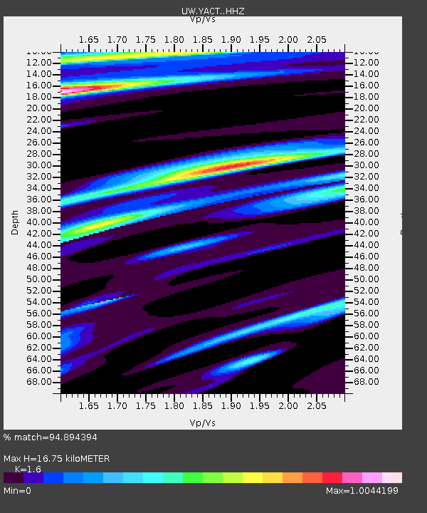
| Estimated Moho Depth: |
16.75 km |
| Estimated Crust Vp/Vs: |
1.60 |
| Assumed Crust Vp: |
6.566 km/s |
| Estimated Crust Vs: |
4.104 km/s |
| Estimated Crust Poisson's Ratio: |
0.18 |
|
| Radial Match: |
94.894394 % |
| Radial Bump: |
400 |
| Transverse Match: |
76.65967 % |
| Transverse Bump: |
400 |
| SOD ConfigId: |
25131211 |
| Insert Time: |
2021-09-22 02:12:52.344 +0000 |
| GWidth: |
2.5 |
| Max Bumps: |
400 |
| Tol: |
0.001 |
|
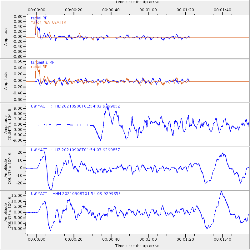
Signal To Noise
| Channel | StoN | STA | LTA |
| UW:YACT: :HHZ:20210908T01:54:03.929985Z | 88.221115 | 1.1119722E-5 | 1.2604377E-7 |
| UW:YACT: :HHN:20210908T01:54:03.929985Z | 62.976547 | 5.670634E-6 | 9.0043585E-8 |
| UW:YACT: :HHE:20210908T01:54:03.929985Z | 42.783104 | 4.657113E-6 | 1.08854024E-7 |
| Arrivals |
| Ps | 1.7 SECOND |
| PpPs | 6.1 SECOND |
| PsPs/PpSs | 7.7 SECOND |


