You are here: Home > Network List > UW - Pacific Northwest Regional Seismic Network Stations List
> Station MULN Lyman, WA, USA > Earthquake Result Viewer
MULN Lyman, WA, USA - Earthquake Result Viewer
| Earthquake location: |
Near Coast Of Guerrero, Mexico |
| Earthquake latitude/longitude: |
17.0/-99.8 |
| Earthquake time(UTC): |
2021/09/08 (251) 01:47:46 GMT |
| Earthquake Depth: |
13 km |
| Earthquake Magnitude: |
7.0 mww |
| Earthquake Catalog/Contributor: |
NEIC PDE/us |
|
| Network: |
UW Pacific Northwest Regional Seismic Network |
| Station: |
MULN Lyman, WA, USA |
| Lat/Lon: |
48.54 N/122.06 W |
| Elevation: |
102 m |
|
| Distance: |
36.4 deg |
| Az: |
334.86 deg |
| Baz: |
142.283 deg |
| Ray Param: |
0.076739326 |
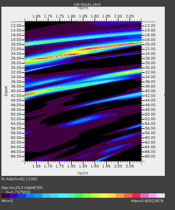
| Estimated Moho Depth: |
25.0 km |
| Estimated Crust Vp/Vs: |
1.74 |
| Assumed Crust Vp: |
6.566 km/s |
| Estimated Crust Vs: |
3.779 km/s |
| Estimated Crust Poisson's Ratio: |
0.25 |
|
| Radial Match: |
92.11081 % |
| Radial Bump: |
247 |
| Transverse Match: |
75.386 % |
| Transverse Bump: |
400 |
| SOD ConfigId: |
25131211 |
| Insert Time: |
2021-09-22 02:13:14.288 +0000 |
| GWidth: |
2.5 |
| Max Bumps: |
400 |
| Tol: |
0.001 |
|

Signal To Noise
| Channel | StoN | STA | LTA |
| UW:MULN: :HHZ:20210908T01:54:19.950005Z | 46.81613 | 9.210236E-6 | 1.9673212E-7 |
| UW:MULN: :HHN:20210908T01:54:19.950005Z | 23.15631 | 4.279394E-6 | 1.8480468E-7 |
| UW:MULN: :HHE:20210908T01:54:19.950005Z | 34.62081 | 3.928862E-6 | 1.1348267E-7 |
| Arrivals |
| Ps | 3.0 SECOND |
| PpPs | 9.6 SECOND |
| PsPs/PpSs | 13 SECOND |


