You are here: Home > Network List > TA - USArray Transportable Network (new EarthScope stations) Stations List
> Station POKR Poker Plat Research Range, AK, USA > Earthquake Result Viewer
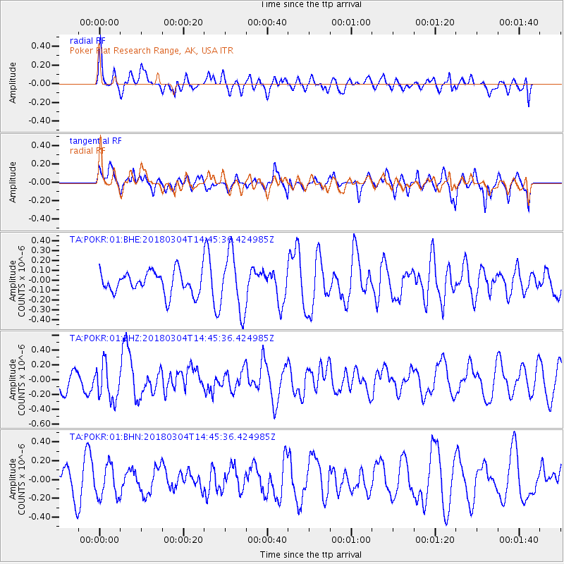
POKR Poker Plat Research Range, AK, USA - Earthquake Result Viewer
*The percent match for this event was below the threshold and hence no stack was calculated.
| Earthquake location: |
New Guinea, Papua New Guinea |
| Earthquake latitude/longitude: |
-6.1/142.7 |
| Earthquake time(UTC): |
2018/03/04 (063) 14:33:21 GMT |
| Earthquake Depth: |
6.0 km |
| Earthquake Magnitude: |
5.7 Mww |
| Earthquake Catalog/Contributor: |
NEIC PDE/us |
|
| Network: |
TA USArray Transportable Network (new EarthScope stations) |
| Station: |
POKR Poker Plat Research Range, AK, USA |
| Lat/Lon: |
65.12 N/147.43 W |
| Elevation: |
501 m |
|
| Distance: |
87.1 deg |
| Az: |
23.433 deg |
| Baz: |
249.183 deg |
| Ray Param: |
$rayparam |
*The percent match for this event was below the threshold and hence was not used in the summary stack. |
|
| Radial Match: |
43.18768 % |
| Radial Bump: |
400 |
| Transverse Match: |
56.558777 % |
| Transverse Bump: |
400 |
| SOD ConfigId: |
2615551 |
| Insert Time: |
2018-03-18 14:35:03.766 +0000 |
| GWidth: |
2.5 |
| Max Bumps: |
400 |
| Tol: |
0.001 |
|
Signal To Noise
| Channel | StoN | STA | LTA |
| TA:POKR:01:BHZ:20180304T14:45:36.424985Z | 1.5094773 | 2.4806508E-7 | 1.6433839E-7 |
| TA:POKR:01:BHN:20180304T14:45:36.424985Z | 1.21914 | 1.7240849E-7 | 1.4141811E-7 |
| TA:POKR:01:BHE:20180304T14:45:36.424985Z | 2.6835632 | 2.9663158E-7 | 1.1053646E-7 |
| Arrivals |
| Ps | |
| PpPs | |
| PsPs/PpSs | |


