You are here: Home > Network List > IU - Global Seismograph Network (GSN - IRIS/USGS) Stations List
> Station NWAO Narrogin, Australia > Earthquake Result Viewer
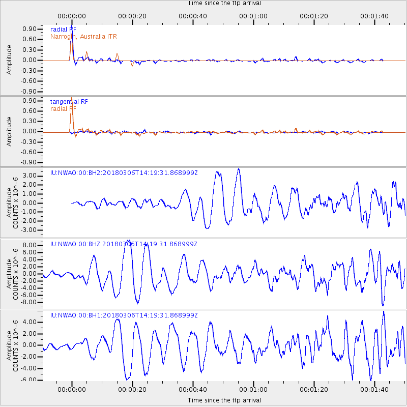
NWAO Narrogin, Australia - Earthquake Result Viewer

| Earthquake location: |
New Guinea, Papua New Guinea |
| Earthquake latitude/longitude: |
-6.3/142.6 |
| Earthquake time(UTC): |
2018/03/06 (065) 14:13:06 GMT |
| Earthquake Depth: |
10 km |
| Earthquake Magnitude: |
6.7 Mww |
| Earthquake Catalog/Contributor: |
NEIC PDE/us |
|
| Network: |
IU Global Seismograph Network (GSN - IRIS/USGS) |
| Station: |
NWAO Narrogin, Australia |
| Lat/Lon: |
32.93 S/117.24 E |
| Elevation: |
380 m |
|
| Distance: |
35.5 deg |
| Az: |
218.374 deg |
| Baz: |
47.202 deg |
| Ray Param: |
0.07720018 |
| Estimated Moho Depth: |
43.0 km |
| Estimated Crust Vp/Vs: |
1.75 |
| Assumed Crust Vp: |
6.419 km/s |
| Estimated Crust Vs: |
3.658 km/s |
| Estimated Crust Poisson's Ratio: |
0.26 |
|
| Radial Match: |
96.27603 % |
| Radial Bump: |
233 |
| Transverse Match: |
81.06839 % |
| Transverse Bump: |
379 |
| SOD ConfigId: |
2615551 |
| Insert Time: |
2018-03-20 14:14:47.356 +0000 |
| GWidth: |
2.5 |
| Max Bumps: |
400 |
| Tol: |
0.001 |
|
Signal To Noise
| Channel | StoN | STA | LTA |
| IU:NWAO:00:BHZ:20180306T14:19:31.868999Z | 3.0222402 | 1.0774859E-6 | 3.5651897E-7 |
| IU:NWAO:00:BH1:20180306T14:19:31.868999Z | 2.40017 | 6.9299267E-7 | 2.8872648E-7 |
| IU:NWAO:00:BH2:20180306T14:19:31.868999Z | 1.4174187 | 3.971869E-7 | 2.8021847E-7 |
| Arrivals |
| Ps | 5.5 SECOND |
| PpPs | 17 SECOND |
| PsPs/PpSs | 23 SECOND |


