You are here: Home > Network List > GM - US Geological Survey Networks Stations List
> Station IWM01 Jericho 2M Well Monitoring Station > Earthquake Result Viewer
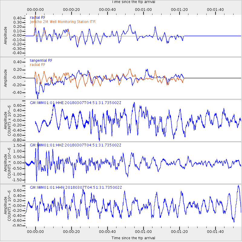
IWM01 Jericho 2M Well Monitoring Station - Earthquake Result Viewer
*The percent match for this event was below the threshold and hence no stack was calculated.
| Earthquake location: |
East Of Kuril Islands |
| Earthquake latitude/longitude: |
45.8/152.3 |
| Earthquake time(UTC): |
2018/03/07 (066) 04:40:12 GMT |
| Earthquake Depth: |
29 km |
| Earthquake Magnitude: |
5.8 Mww |
| Earthquake Catalog/Contributor: |
NEIC PDE/us |
|
| Network: |
GM US Geological Survey Networks |
| Station: |
IWM01 Jericho 2M Well Monitoring Station |
| Lat/Lon: |
36.73 N/96.53 W |
| Elevation: |
328 m |
|
| Distance: |
77.1 deg |
| Az: |
50.214 deg |
| Baz: |
318.024 deg |
| Ray Param: |
$rayparam |
*The percent match for this event was below the threshold and hence was not used in the summary stack. |
|
| Radial Match: |
50.130405 % |
| Radial Bump: |
400 |
| Transverse Match: |
68.33539 % |
| Transverse Bump: |
400 |
| SOD ConfigId: |
2615551 |
| Insert Time: |
2018-03-21 04:41:41.474 +0000 |
| GWidth: |
2.5 |
| Max Bumps: |
400 |
| Tol: |
0.001 |
|
Signal To Noise
| Channel | StoN | STA | LTA |
| GM:IWM01:01:HHZ:20180307T04:51:31.735002Z | 1.8487445 | 6.7682544E-7 | 3.661E-7 |
| GM:IWM01:01:HHN:20180307T04:51:31.735002Z | 1.1225215 | 2.6056372E-7 | 2.3212357E-7 |
| GM:IWM01:01:HHE:20180307T04:51:31.735002Z | 0.9018477 | 2.315582E-7 | 2.5675976E-7 |
| Arrivals |
| Ps | |
| PpPs | |
| PsPs/PpSs | |


