You are here: Home > Network List > IU - Global Seismograph Network (GSN - IRIS/USGS) Stations List
> Station PMG Port Moresby, New Guinea > Earthquake Result Viewer
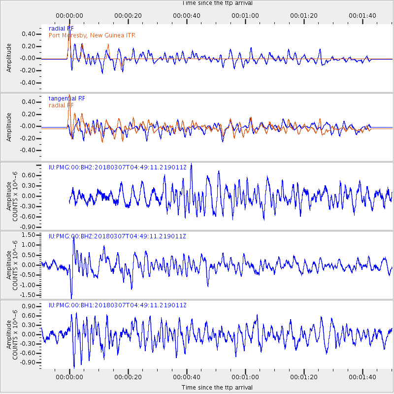
PMG Port Moresby, New Guinea - Earthquake Result Viewer
*The percent match for this event was below the threshold and hence no stack was calculated.
| Earthquake location: |
East Of Kuril Islands |
| Earthquake latitude/longitude: |
45.8/152.3 |
| Earthquake time(UTC): |
2018/03/07 (066) 04:40:12 GMT |
| Earthquake Depth: |
29 km |
| Earthquake Magnitude: |
5.8 Mww |
| Earthquake Catalog/Contributor: |
NEIC PDE/us |
|
| Network: |
IU Global Seismograph Network (GSN - IRIS/USGS) |
| Station: |
PMG Port Moresby, New Guinea |
| Lat/Lon: |
9.40 S/147.16 E |
| Elevation: |
90 m |
|
| Distance: |
55.2 deg |
| Az: |
186.17 deg |
| Baz: |
4.368 deg |
| Ray Param: |
$rayparam |
*The percent match for this event was below the threshold and hence was not used in the summary stack. |
|
| Radial Match: |
65.957016 % |
| Radial Bump: |
400 |
| Transverse Match: |
48.866707 % |
| Transverse Bump: |
400 |
| SOD ConfigId: |
2615551 |
| Insert Time: |
2018-03-21 04:42:36.722 +0000 |
| GWidth: |
2.5 |
| Max Bumps: |
400 |
| Tol: |
0.001 |
|
Signal To Noise
| Channel | StoN | STA | LTA |
| IU:PMG:00:BHZ:20180307T04:49:11.219011Z | 4.5338435 | 6.8341234E-7 | 1.5073576E-7 |
| IU:PMG:00:BH1:20180307T04:49:11.219011Z | 3.3832355 | 4.7764115E-7 | 1.4117882E-7 |
| IU:PMG:00:BH2:20180307T04:49:11.219011Z | 1.6016017 | 2.5937777E-7 | 1.6194899E-7 |
| Arrivals |
| Ps | |
| PpPs | |
| PsPs/PpSs | |


