You are here: Home > Network List > IU - Global Seismograph Network (GSN - IRIS/USGS) Stations List
> Station RSSD Black Hills, South Dakota, USA > Earthquake Result Viewer
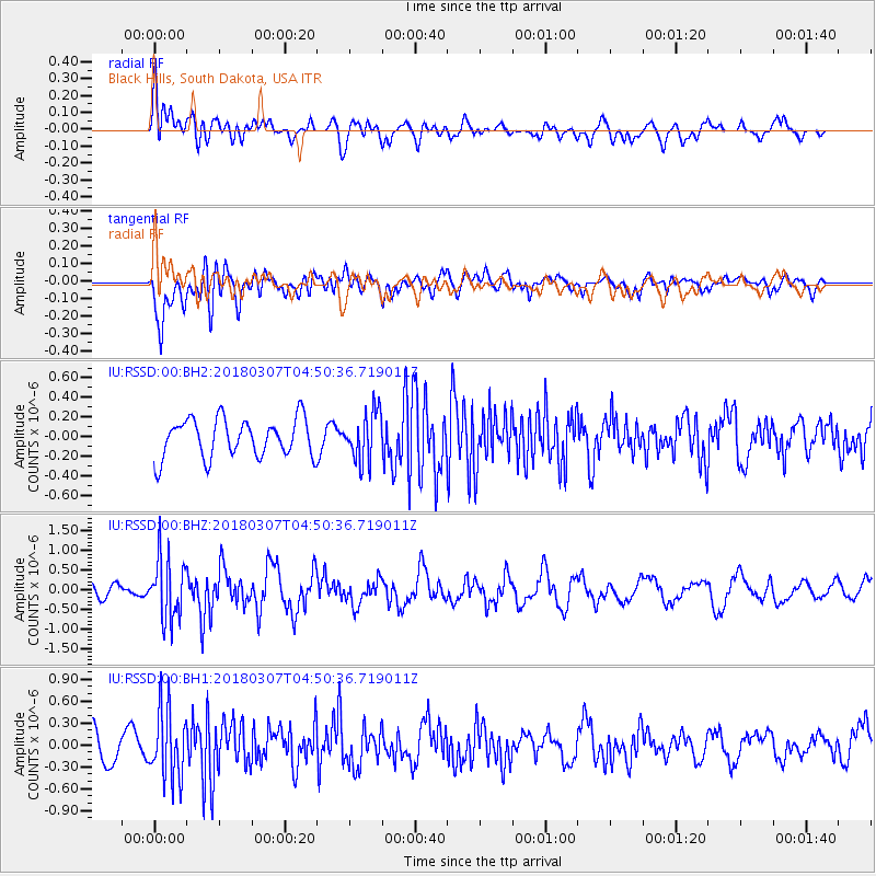
RSSD Black Hills, South Dakota, USA - Earthquake Result Viewer
*The percent match for this event was below the threshold and hence no stack was calculated.
| Earthquake location: |
East Of Kuril Islands |
| Earthquake latitude/longitude: |
45.8/152.3 |
| Earthquake time(UTC): |
2018/03/07 (066) 04:40:12 GMT |
| Earthquake Depth: |
29 km |
| Earthquake Magnitude: |
5.8 Mww |
| Earthquake Catalog/Contributor: |
NEIC PDE/us |
|
| Network: |
IU Global Seismograph Network (GSN - IRIS/USGS) |
| Station: |
RSSD Black Hills, South Dakota, USA |
| Lat/Lon: |
44.12 N/104.04 W |
| Elevation: |
2090 m |
|
| Distance: |
67.9 deg |
| Az: |
49.069 deg |
| Baz: |
312.817 deg |
| Ray Param: |
$rayparam |
*The percent match for this event was below the threshold and hence was not used in the summary stack. |
|
| Radial Match: |
73.22254 % |
| Radial Bump: |
400 |
| Transverse Match: |
74.23303 % |
| Transverse Bump: |
400 |
| SOD ConfigId: |
2615551 |
| Insert Time: |
2018-03-21 04:42:39.747 +0000 |
| GWidth: |
2.5 |
| Max Bumps: |
400 |
| Tol: |
0.001 |
|
Signal To Noise
| Channel | StoN | STA | LTA |
| IU:RSSD:00:BHZ:20180307T04:50:36.719011Z | 3.6435788 | 7.7296374E-7 | 2.121441E-7 |
| IU:RSSD:00:BH1:20180307T04:50:36.719011Z | 2.7420337 | 4.7560553E-7 | 1.7344992E-7 |
| IU:RSSD:00:BH2:20180307T04:50:36.719011Z | 1.2658952 | 2.4874515E-7 | 1.9649742E-7 |
| Arrivals |
| Ps | |
| PpPs | |
| PsPs/PpSs | |


