You are here: Home > Network List > US - United States National Seismic Network Stations List
> Station AGMN Agassiz National Wildlife Refuge, Minnesota, USA > Earthquake Result Viewer
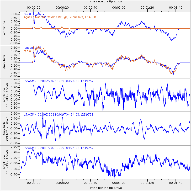
AGMN Agassiz National Wildlife Refuge, Minnesota, USA - Earthquake Result Viewer
*The percent match for this event was below the threshold and hence no stack was calculated.
| Earthquake location: |
Southeast Of Honshu, Japan |
| Earthquake latitude/longitude: |
29.3/142.2 |
| Earthquake time(UTC): |
2021/09/09 (252) 04:11:49 GMT |
| Earthquake Depth: |
10 km |
| Earthquake Magnitude: |
5.4 Mww |
| Earthquake Catalog/Contributor: |
NEIC PDE/us |
|
| Network: |
US United States National Seismic Network |
| Station: |
AGMN Agassiz National Wildlife Refuge, Minnesota, USA |
| Lat/Lon: |
48.30 N/95.86 W |
| Elevation: |
351 m |
|
| Distance: |
86.9 deg |
| Az: |
34.57 deg |
| Baz: |
312.098 deg |
| Ray Param: |
$rayparam |
*The percent match for this event was below the threshold and hence was not used in the summary stack. |
|
| Radial Match: |
44.94431 % |
| Radial Bump: |
400 |
| Transverse Match: |
42.797504 % |
| Transverse Bump: |
400 |
| SOD ConfigId: |
25131211 |
| Insert Time: |
2021-09-23 04:28:23.679 +0000 |
| GWidth: |
2.5 |
| Max Bumps: |
400 |
| Tol: |
0.001 |
|
Signal To Noise
| Channel | StoN | STA | LTA |
| US:AGMN:00:BHZ:20210909T04:24:03.123975Z | 1.2410562 | 1.4274134E-7 | 1.1501602E-7 |
| US:AGMN:00:BH1:20210909T04:24:03.123975Z | 3.07247 | 8.5838303E-7 | 2.7937884E-7 |
| US:AGMN:00:BH2:20210909T04:24:03.123975Z | 1.4532056 | 1.5038387E-7 | 1.0348424E-7 |
| Arrivals |
| Ps | |
| PpPs | |
| PsPs/PpSs | |


