You are here: Home > Network List > US - United States National Seismic Network Stations List
> Station MSO Missoula, Montana, USA > Earthquake Result Viewer
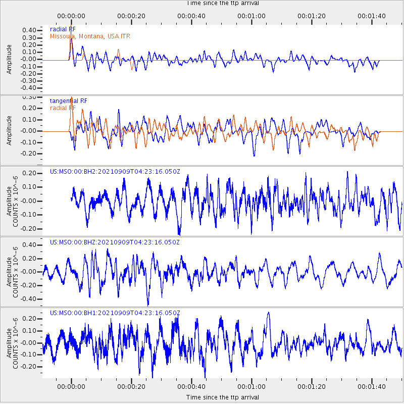
MSO Missoula, Montana, USA - Earthquake Result Viewer
*The percent match for this event was below the threshold and hence no stack was calculated.
| Earthquake location: |
Southeast Of Honshu, Japan |
| Earthquake latitude/longitude: |
29.3/142.2 |
| Earthquake time(UTC): |
2021/09/09 (252) 04:11:49 GMT |
| Earthquake Depth: |
10 km |
| Earthquake Magnitude: |
5.4 Mww |
| Earthquake Catalog/Contributor: |
NEIC PDE/us |
|
| Network: |
US United States National Seismic Network |
| Station: |
MSO Missoula, Montana, USA |
| Lat/Lon: |
46.83 N/113.94 W |
| Elevation: |
1264 m |
|
| Distance: |
77.8 deg |
| Az: |
42.99 deg |
| Baz: |
299.868 deg |
| Ray Param: |
$rayparam |
*The percent match for this event was below the threshold and hence was not used in the summary stack. |
|
| Radial Match: |
53.487106 % |
| Radial Bump: |
400 |
| Transverse Match: |
56.1966 % |
| Transverse Bump: |
400 |
| SOD ConfigId: |
25131211 |
| Insert Time: |
2021-09-23 04:28:40.084 +0000 |
| GWidth: |
2.5 |
| Max Bumps: |
400 |
| Tol: |
0.001 |
|
Signal To Noise
| Channel | StoN | STA | LTA |
| US:MSO:00:BHZ:20210909T04:23:16.050Z | 2.4999843 | 1.4296573E-7 | 5.7186654E-8 |
| US:MSO:00:BH1:20210909T04:23:16.050Z | 1.0120847 | 6.863329E-8 | 6.781379E-8 |
| US:MSO:00:BH2:20210909T04:23:16.050Z | 1.0099461 | 6.2863606E-8 | 6.224452E-8 |
| Arrivals |
| Ps | |
| PpPs | |
| PsPs/PpSs | |


