You are here: Home > Network List > AV - Alaska Volcano Observatory Stations List
> Station SPCR Ckakachatna River, Mount Spurr, Alaska > Earthquake Result Viewer
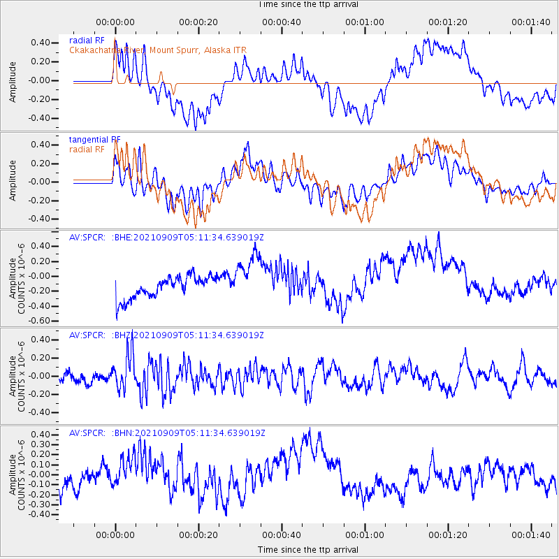
SPCR Ckakachatna River, Mount Spurr, Alaska - Earthquake Result Viewer
*The percent match for this event was below the threshold and hence no stack was calculated.
| Earthquake location: |
Fiji Islands Region |
| Earthquake latitude/longitude: |
-19.1/-176.4 |
| Earthquake time(UTC): |
2021/09/09 (252) 04:59:43 GMT |
| Earthquake Depth: |
10 km |
| Earthquake Magnitude: |
5.8 Mww |
| Earthquake Catalog/Contributor: |
NEIC PDE/us |
|
| Network: |
AV Alaska Volcano Observatory |
| Station: |
SPCR Ckakachatna River, Mount Spurr, Alaska |
| Lat/Lon: |
61.20 N/152.21 W |
| Elevation: |
984 m |
|
| Distance: |
82.4 deg |
| Az: |
11.57 deg |
| Baz: |
203.052 deg |
| Ray Param: |
$rayparam |
*The percent match for this event was below the threshold and hence was not used in the summary stack. |
|
| Radial Match: |
39.036 % |
| Radial Bump: |
400 |
| Transverse Match: |
36.841576 % |
| Transverse Bump: |
400 |
| SOD ConfigId: |
25131211 |
| Insert Time: |
2021-09-23 05:04:44.707 +0000 |
| GWidth: |
2.5 |
| Max Bumps: |
400 |
| Tol: |
0.001 |
|
Signal To Noise
| Channel | StoN | STA | LTA |
| AV:SPCR: :BHZ:20210909T05:11:34.639019Z | 3.3467784 | 2.0033475E-7 | 5.985898E-8 |
| AV:SPCR: :BHN:20210909T05:11:34.639019Z | 2.0611982 | 1.910478E-7 | 9.2687735E-8 |
| AV:SPCR: :BHE:20210909T05:11:34.639019Z | 2.336649 | 3.4510884E-7 | 1.4769391E-7 |
| Arrivals |
| Ps | |
| PpPs | |
| PsPs/PpSs | |


