You are here: Home > Network List > NO - Norwegian Seismic Array Network Stations List
> Station SPB1 > Earthquake Result Viewer
SPB1 - Earthquake Result Viewer
| Earthquake location: |
East Of Kuril Islands |
| Earthquake latitude/longitude: |
45.8/152.3 |
| Earthquake time(UTC): |
2018/03/07 (066) 04:40:12 GMT |
| Earthquake Depth: |
29 km |
| Earthquake Magnitude: |
5.8 Mww |
| Earthquake Catalog/Contributor: |
NEIC PDE/us |
|
| Network: |
NO Norwegian Seismic Array Network |
| Station: |
SPB1 |
| Lat/Lon: |
78.18 N/16.39 E |
| Elevation: |
301 m |
|
| Distance: |
53.4 deg |
| Az: |
349.707 deg |
| Baz: |
37.302 deg |
| Ray Param: |
0.06606187 |
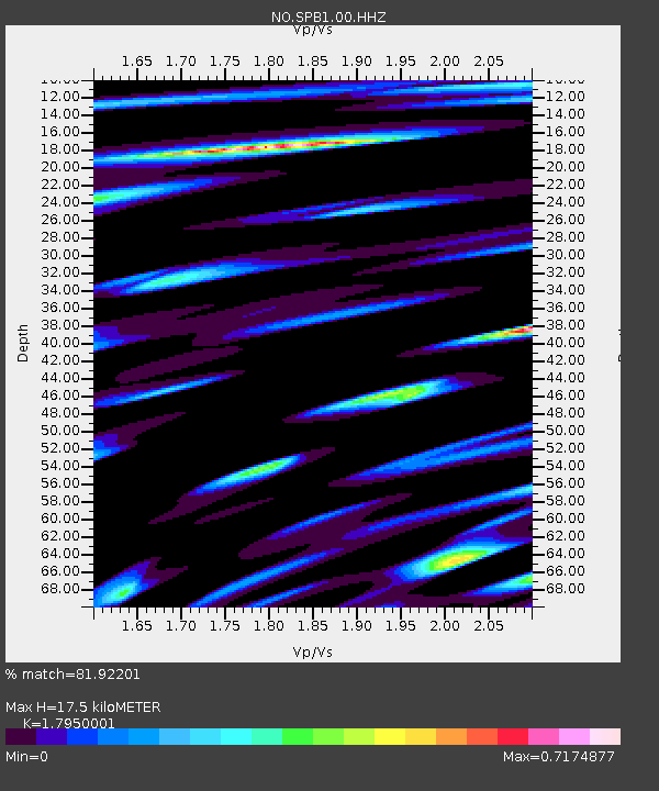
| Estimated Moho Depth: |
17.5 km |
| Estimated Crust Vp/Vs: |
1.80 |
| Assumed Crust Vp: |
6.545 km/s |
| Estimated Crust Vs: |
3.646 km/s |
| Estimated Crust Poisson's Ratio: |
0.27 |
|
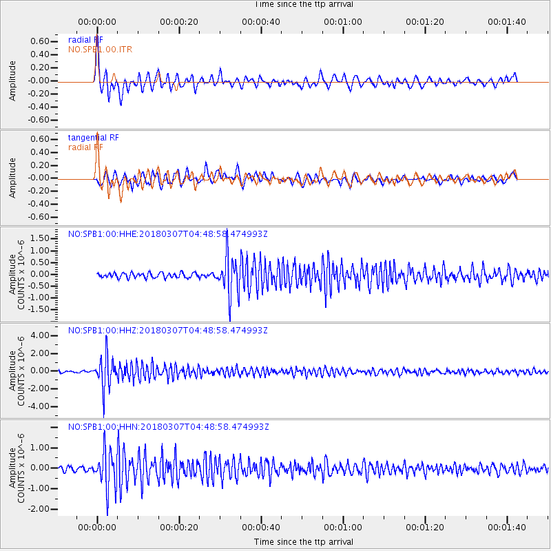
| Radial Match: |
81.92201 % |
| Radial Bump: |
400 |
| Transverse Match: |
79.36936 % |
| Transverse Bump: |
400 |
| SOD ConfigId: |
2615551 |
| Insert Time: |
2018-03-21 04:43:44.071 +0000 |
| GWidth: |
2.5 |
| Max Bumps: |
400 |
| Tol: |
0.001 |
|
Signal To Noise
| Channel | StoN | STA | LTA |
| NO:SPB1:00:HHZ:20180307T04:48:58.474993Z | 14.778797 | 1.7761399E-6 | 1.2018162E-7 |
| NO:SPB1:00:HHN:20180307T04:48:58.474993Z | 8.36522 | 9.12415E-7 | 1.09072445E-7 |
| NO:SPB1:00:HHE:20180307T04:48:58.474993Z | 7.9907055 | 8.1595556E-7 | 1.0211308E-7 |
| Arrivals |
| Ps | 2.2 SECOND |
| PpPs | 7.1 SECOND |
| PsPs/PpSs | 9.3 SECOND |


