You are here: Home > Network List > NR - NARS Array Stations List
> Station NE72 Camalu, Mexico > Earthquake Result Viewer
NE72 Camalu, Mexico - Earthquake Result Viewer
| Earthquake location: |
Sea Of Okhotsk |
| Earthquake latitude/longitude: |
53.9/152.9 |
| Earthquake time(UTC): |
2008/07/05 (187) 02:12:04 GMT |
| Earthquake Depth: |
633 km |
| Earthquake Magnitude: |
6.8 MB, 7.7 MW, 7.7 MW |
| Earthquake Catalog/Contributor: |
WHDF/NEIC |
|
| Network: |
NR NARS Array |
| Station: |
NE72 Camalu, Mexico |
| Lat/Lon: |
30.85 N/116.06 W |
| Elevation: |
17 m |
|
| Distance: |
66.3 deg |
| Az: |
69.89 deg |
| Baz: |
319.728 deg |
| Ray Param: |
0.055334803 |
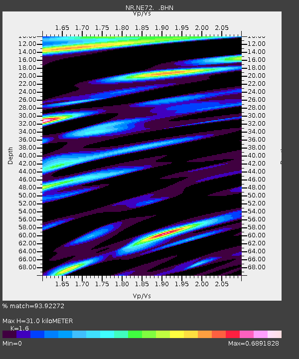
| Estimated Moho Depth: |
31.0 km |
| Estimated Crust Vp/Vs: |
1.60 |
| Assumed Crust Vp: |
6.183 km/s |
| Estimated Crust Vs: |
3.864 km/s |
| Estimated Crust Poisson's Ratio: |
0.18 |
|
| Radial Match: |
93.92272 % |
| Radial Bump: |
400 |
| Transverse Match: |
92.32368 % |
| Transverse Bump: |
400 |
| SOD ConfigId: |
2658 |
| Insert Time: |
2010-03-09 12:40:09.408 +0000 |
| GWidth: |
2.5 |
| Max Bumps: |
400 |
| Tol: |
0.001 |
|

Signal To Noise
| Channel | StoN | STA | LTA |
| NR:NE72: :BHN:20080705T02:21:21.295002Z | 24.479565 | 4.7391513E-6 | 1.9359622E-7 |
| NR:NE72: :BHE:20080705T02:21:21.295002Z | 6.0119987 | 2.0573182E-6 | 3.4220204E-7 |
| NR:NE72: :BHZ:20080705T02:21:21.295002Z | 7.68563 | 2.0704379E-6 | 2.693908E-7 |
| Arrivals |
| Ps | 3.1 SECOND |
| PpPs | 13 SECOND |
| PsPs/PpSs | 16 SECOND |


