You are here: Home > Network List > NR - NARS Array Stations List
> Station NE72 Camalu, Mexico > Earthquake Result Viewer
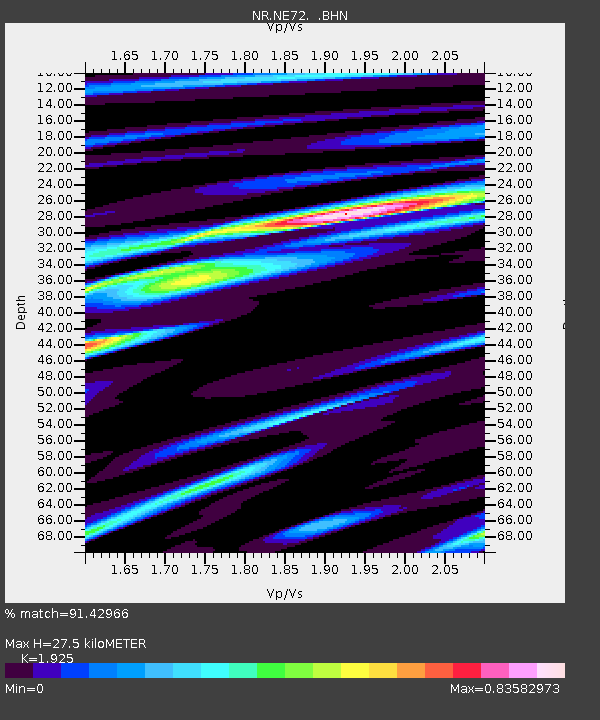
NE72 Camalu, Mexico - Earthquake Result Viewer
| Earthquake location: |
Northern Peru |
| Earthquake latitude/longitude: |
-5.7/-76.4 |
| Earthquake time(UTC): |
2005/09/26 (269) 01:55:37 GMT |
| Earthquake Depth: |
115 km |
| Earthquake Magnitude: |
6.7 MB, 7.5 MW, 7.5 MW |
| Earthquake Catalog/Contributor: |
WHDF/NEIC |
|
| Network: |
NR NARS Array |
| Station: |
NE72 Camalu, Mexico |
| Lat/Lon: |
30.85 N/116.06 W |
| Elevation: |
17 m |
|
| Distance: |
52.5 deg |
| Az: |
316.222 deg |
| Baz: |
126.816 deg |
| Ray Param: |
0.06634562 |
| Estimated Moho Depth: |
27.5 km |
| Estimated Crust Vp/Vs: |
1.92 |
| Assumed Crust Vp: |
6.183 km/s |
| Estimated Crust Vs: |
3.212 km/s |
| Estimated Crust Poisson's Ratio: |
0.32 |
|
| Radial Match: |
91.42966 % |
| Radial Bump: |
400 |
| Transverse Match: |
78.82423 % |
| Transverse Bump: |
400 |
| SOD ConfigId: |
2564 |
| Insert Time: |
2010-03-09 12:40:16.098 +0000 |
| GWidth: |
2.5 |
| Max Bumps: |
400 |
| Tol: |
0.001 |
|

Signal To Noise
| Channel | StoN | STA | LTA |
| NR:NE72: :BHN:20050926T02:04:08.353014Z | 3.068957 | 5.2409973E-6 | 1.7077455E-6 |
| NR:NE72: :BHE:20050926T02:04:08.353014Z | 17.23319 | 6.1420965E-6 | 3.5641085E-7 |
| NR:NE72: :BHZ:20050926T02:04:08.353014Z | 37.47066 | 1.4104468E-5 | 3.7641362E-7 |
| Arrivals |
| Ps | 4.3 SECOND |
| PpPs | 12 SECOND |
| PsPs/PpSs | 17 SECOND |


