You are here: Home > Network List > NR - NARS Array Stations List
> Station NE72 Camalu, Mexico > Earthquake Result Viewer
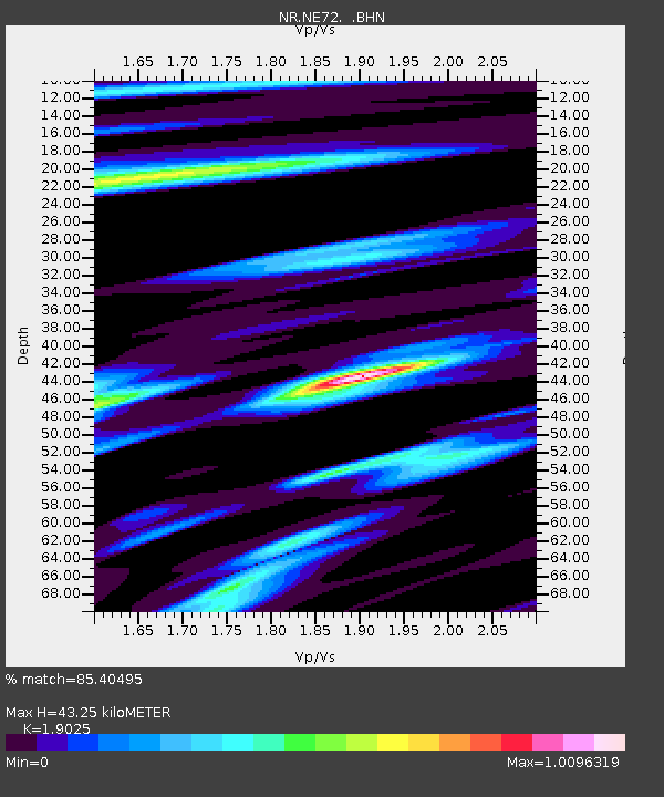
NE72 Camalu, Mexico - Earthquake Result Viewer
| Earthquake location: |
South Of Fiji Islands |
| Earthquake latitude/longitude: |
-23.6/-180.0 |
| Earthquake time(UTC): |
2006/02/26 (057) 03:08:27 GMT |
| Earthquake Depth: |
535 km |
| Earthquake Magnitude: |
5.9 MB, 6.4 MW, 6.4 MW |
| Earthquake Catalog/Contributor: |
WHDF/NEIC |
|
| Network: |
NR NARS Array |
| Station: |
NE72 Camalu, Mexico |
| Lat/Lon: |
30.85 N/116.06 W |
| Elevation: |
17 m |
|
| Distance: |
81.7 deg |
| Az: |
51.317 deg |
| Baz: |
236.366 deg |
| Ray Param: |
0.045790985 |
| Estimated Moho Depth: |
43.25 km |
| Estimated Crust Vp/Vs: |
1.90 |
| Assumed Crust Vp: |
6.183 km/s |
| Estimated Crust Vs: |
3.25 km/s |
| Estimated Crust Poisson's Ratio: |
0.31 |
|
| Radial Match: |
85.40495 % |
| Radial Bump: |
400 |
| Transverse Match: |
84.25728 % |
| Transverse Bump: |
400 |
| SOD ConfigId: |
5423 |
| Insert Time: |
2010-03-09 12:40:21.822 +0000 |
| GWidth: |
2.5 |
| Max Bumps: |
400 |
| Tol: |
0.001 |
|

Signal To Noise
| Channel | StoN | STA | LTA |
| NR:NE72: :BHN:20060226T03:19:19.341006Z | 3.5263035 | 7.763668E-7 | 2.2016448E-7 |
| NR:NE72: :BHE:20060226T03:19:19.341006Z | 4.609795 | 1.2885375E-6 | 2.7952163E-7 |
| NR:NE72: :BHZ:20060226T03:19:19.341006Z | 15.43851 | 3.959799E-6 | 2.564884E-7 |
| Arrivals |
| Ps | 6.5 SECOND |
| PpPs | 20 SECOND |
| PsPs/PpSs | 26 SECOND |


