You are here: Home > Network List > NR - NARS Array Stations List
> Station NE72 Camalu, Mexico > Earthquake Result Viewer
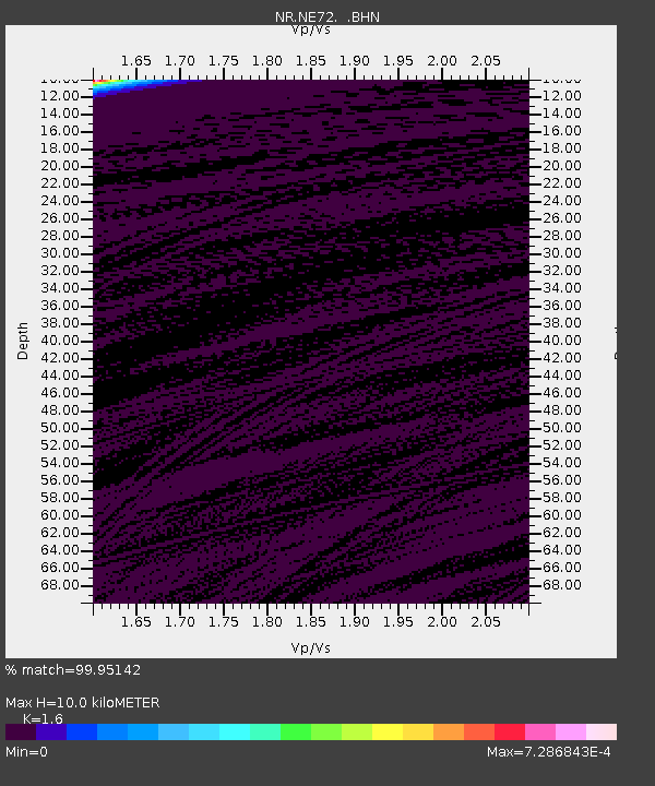
NE72 Camalu, Mexico - Earthquake Result Viewer
| Earthquake location: |
Near West Coast Of Colombia |
| Earthquake latitude/longitude: |
6.9/-77.8 |
| Earthquake time(UTC): |
2006/01/23 (023) 20:50:44 GMT |
| Earthquake Depth: |
14 km |
| Earthquake Magnitude: |
6.1 MB, 5.9 MS, 6.2 MW, 6.1 MW |
| Earthquake Catalog/Contributor: |
WHDF/NEIC |
|
| Network: |
NR NARS Array |
| Station: |
NE72 Camalu, Mexico |
| Lat/Lon: |
30.85 N/116.06 W |
| Elevation: |
17 m |
|
| Distance: |
43.0 deg |
| Az: |
308.683 deg |
| Baz: |
115.679 deg |
| Ray Param: |
0.07280634 |
| Estimated Moho Depth: |
10.0 km |
| Estimated Crust Vp/Vs: |
1.60 |
| Assumed Crust Vp: |
6.183 km/s |
| Estimated Crust Vs: |
3.864 km/s |
| Estimated Crust Poisson's Ratio: |
0.18 |
|
| Radial Match: |
99.95142 % |
| Radial Bump: |
7 |
| Transverse Match: |
99.809105 % |
| Transverse Bump: |
32 |
| SOD ConfigId: |
5423 |
| Insert Time: |
2010-03-09 12:40:24.264 +0000 |
| GWidth: |
2.5 |
| Max Bumps: |
400 |
| Tol: |
0.001 |
|

Signal To Noise
| Channel | StoN | STA | LTA |
| NR:NE72: :BHN:20060123T20:58:13.111012Z | 0.4620737 | 3.3305176E-7 | 7.2077626E-7 |
| NR:NE72: :BHE:20060123T20:58:13.111012Z | 1.2569181 | 1.166026E-5 | 9.276866E-6 |
| NR:NE72: :BHZ:20060123T20:58:13.111012Z | 1.3125107 | 8.504459E-6 | 6.479535E-6 |
| Arrivals |
| Ps | 1.0 SECOND |
| PpPs | 3.9 SECOND |
| PsPs/PpSs | 5.0 SECOND |


