You are here: Home > Network List > NR - NARS Array Stations List
> Station NE72 Camalu, Mexico > Earthquake Result Viewer
NE72 Camalu, Mexico - Earthquake Result Viewer
| Earthquake location: |
Vanuatu Islands |
| Earthquake latitude/longitude: |
-13.5/167.0 |
| Earthquake time(UTC): |
2008/09/08 (252) 18:52:06 GMT |
| Earthquake Depth: |
110 km |
| Earthquake Magnitude: |
6.4 MB, 6.9 MW, 6.9 MW |
| Earthquake Catalog/Contributor: |
WHDF/NEIC |
|
| Network: |
NR NARS Array |
| Station: |
NE72 Camalu, Mexico |
| Lat/Lon: |
30.85 N/116.06 W |
| Elevation: |
17 m |
|
| Distance: |
86.0 deg |
| Az: |
57.138 deg |
| Baz: |
251.811 deg |
| Ray Param: |
0.044148058 |
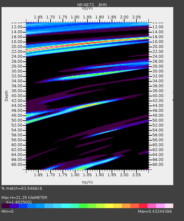
| Estimated Moho Depth: |
21.25 km |
| Estimated Crust Vp/Vs: |
1.60 |
| Assumed Crust Vp: |
6.183 km/s |
| Estimated Crust Vs: |
3.858 km/s |
| Estimated Crust Poisson's Ratio: |
0.18 |
|
| Radial Match: |
83.546616 % |
| Radial Bump: |
400 |
| Transverse Match: |
73.78798 % |
| Transverse Bump: |
400 |
| SOD ConfigId: |
2560 |
| Insert Time: |
2010-03-09 12:40:41.438 +0000 |
| GWidth: |
2.5 |
| Max Bumps: |
400 |
| Tol: |
0.001 |
|

Signal To Noise
| Channel | StoN | STA | LTA |
| NR:NE72: :BHN:20080908T19:04:03.821013Z | 12.312335 | 4.812802E-6 | 3.9089275E-7 |
| NR:NE72: :BHE:20080908T19:04:03.821013Z | 1.4281789 | 1.3012797E-6 | 9.111461E-7 |
| NR:NE72: :BHZ:20080908T19:04:03.821013Z | 2.8377132 | 2.020043E-6 | 7.118559E-7 |
| Arrivals |
| Ps | 2.1 SECOND |
| PpPs | 8.7 SECOND |
| PsPs/PpSs | 11 SECOND |


