You are here: Home > Network List > CI - Caltech Regional Seismic Network Stations List
> Station MPM Manuel Prospect Mine, California, USA > Earthquake Result Viewer
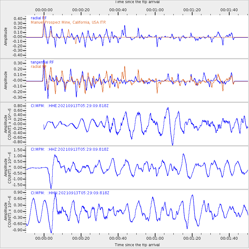
MPM Manuel Prospect Mine, California, USA - Earthquake Result Viewer
*The percent match for this event was below the threshold and hence no stack was calculated.
| Earthquake location: |
Chile-Argentina Border Region |
| Earthquake latitude/longitude: |
-23.9/-67.0 |
| Earthquake time(UTC): |
2021/09/13 (256) 05:18:13 GMT |
| Earthquake Depth: |
193 km |
| Earthquake Magnitude: |
6.2 mww |
| Earthquake Catalog/Contributor: |
NEIC PDE/us |
|
| Network: |
CI Caltech Regional Seismic Network |
| Station: |
MPM Manuel Prospect Mine, California, USA |
| Lat/Lon: |
36.06 N/117.49 W |
| Elevation: |
185 m |
|
| Distance: |
76.3 deg |
| Az: |
319.97 deg |
| Baz: |
133.401 deg |
| Ray Param: |
$rayparam |
*The percent match for this event was below the threshold and hence was not used in the summary stack. |
|
| Radial Match: |
58.441586 % |
| Radial Bump: |
400 |
| Transverse Match: |
80.797295 % |
| Transverse Bump: |
400 |
| SOD ConfigId: |
25131211 |
| Insert Time: |
2021-09-27 05:23:04.371 +0000 |
| GWidth: |
2.5 |
| Max Bumps: |
400 |
| Tol: |
0.001 |
|
Signal To Noise
| Channel | StoN | STA | LTA |
| CI:MPM: :HHZ:20210913T05:29:09.818Z | 4.380252 | 7.4514503E-7 | 1.7011466E-7 |
| CI:MPM: :HHN:20210913T05:29:09.818Z | 1.3774039 | 5.500625E-7 | 3.9934733E-7 |
| CI:MPM: :HHE:20210913T05:29:09.818Z | 1.2631849 | 1.613943E-7 | 1.2776776E-7 |
| Arrivals |
| Ps | |
| PpPs | |
| PsPs/PpSs | |


