You are here: Home > Network List > US - United States National Seismic Network Stations List
> Station ELK Elko, Nevada, USA > Earthquake Result Viewer
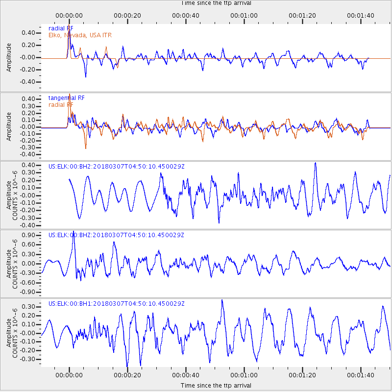
ELK Elko, Nevada, USA - Earthquake Result Viewer
*The percent match for this event was below the threshold and hence no stack was calculated.
| Earthquake location: |
East Of Kuril Islands |
| Earthquake latitude/longitude: |
45.8/152.3 |
| Earthquake time(UTC): |
2018/03/07 (066) 04:40:12 GMT |
| Earthquake Depth: |
29 km |
| Earthquake Magnitude: |
5.8 Mww |
| Earthquake Catalog/Contributor: |
NEIC PDE/us |
|
| Network: |
US United States National Seismic Network |
| Station: |
ELK Elko, Nevada, USA |
| Lat/Lon: |
40.74 N/115.24 W |
| Elevation: |
2210 m |
|
| Distance: |
63.8 deg |
| Az: |
57.798 deg |
| Baz: |
308.853 deg |
| Ray Param: |
$rayparam |
*The percent match for this event was below the threshold and hence was not used in the summary stack. |
|
| Radial Match: |
69.957825 % |
| Radial Bump: |
394 |
| Transverse Match: |
48.521915 % |
| Transverse Bump: |
400 |
| SOD ConfigId: |
2615551 |
| Insert Time: |
2018-03-21 04:45:18.072 +0000 |
| GWidth: |
2.5 |
| Max Bumps: |
400 |
| Tol: |
0.001 |
|
Signal To Noise
| Channel | StoN | STA | LTA |
| US:ELK:00:BHZ:20180307T04:50:10.450029Z | 3.9413452 | 4.126761E-7 | 1.0470437E-7 |
| US:ELK:00:BH1:20180307T04:50:10.450029Z | 0.57748216 | 6.532144E-8 | 1.131142E-7 |
| US:ELK:00:BH2:20180307T04:50:10.450029Z | 0.9313329 | 1.3171106E-7 | 1.414221E-7 |
| Arrivals |
| Ps | |
| PpPs | |
| PsPs/PpSs | |


