You are here: Home > Network List > UW - Pacific Northwest Regional Seismic Network Stations List
> Station UMAT Pilot Rock, OR, USA > Earthquake Result Viewer
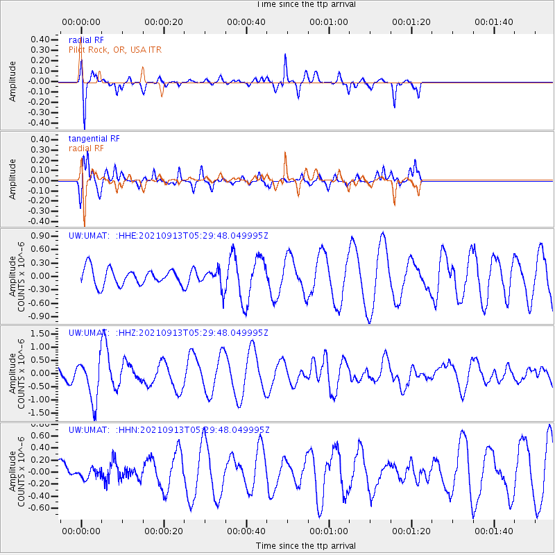
UMAT Pilot Rock, OR, USA - Earthquake Result Viewer
*The percent match for this event was below the threshold and hence no stack was calculated.
| Earthquake location: |
Chile-Argentina Border Region |
| Earthquake latitude/longitude: |
-23.9/-67.0 |
| Earthquake time(UTC): |
2021/09/13 (256) 05:18:13 GMT |
| Earthquake Depth: |
193 km |
| Earthquake Magnitude: |
6.2 mww |
| Earthquake Catalog/Contributor: |
NEIC PDE/us |
|
| Network: |
UW Pacific Northwest Regional Seismic Network |
| Station: |
UMAT Pilot Rock, OR, USA |
| Lat/Lon: |
45.29 N/118.96 W |
| Elevation: |
1318 m |
|
| Distance: |
83.5 deg |
| Az: |
325.984 deg |
| Baz: |
133.498 deg |
| Ray Param: |
$rayparam |
*The percent match for this event was below the threshold and hence was not used in the summary stack. |
|
| Radial Match: |
62.359085 % |
| Radial Bump: |
199 |
| Transverse Match: |
77.64967 % |
| Transverse Bump: |
385 |
| SOD ConfigId: |
25131211 |
| Insert Time: |
2021-09-27 05:42:35.035 +0000 |
| GWidth: |
2.5 |
| Max Bumps: |
400 |
| Tol: |
0.001 |
|
Signal To Noise
| Channel | StoN | STA | LTA |
| UW:UMAT: :HHZ:20210913T05:29:48.049995Z | 2.8789225 | 8.2756657E-7 | 2.8745706E-7 |
| UW:UMAT: :HHN:20210913T05:29:48.049995Z | 0.20461448 | 7.5655805E-8 | 3.6974808E-7 |
| UW:UMAT: :HHE:20210913T05:29:48.049995Z | 1.1574032 | 2.1104975E-7 | 1.8234763E-7 |
| Arrivals |
| Ps | |
| PpPs | |
| PsPs/PpSs | |


