You are here: Home > Network List > WY - Yellowstone Wyoming Seismic Network Stations List
> Station YHH Holmes Hill, YNP, WY, USA > Earthquake Result Viewer
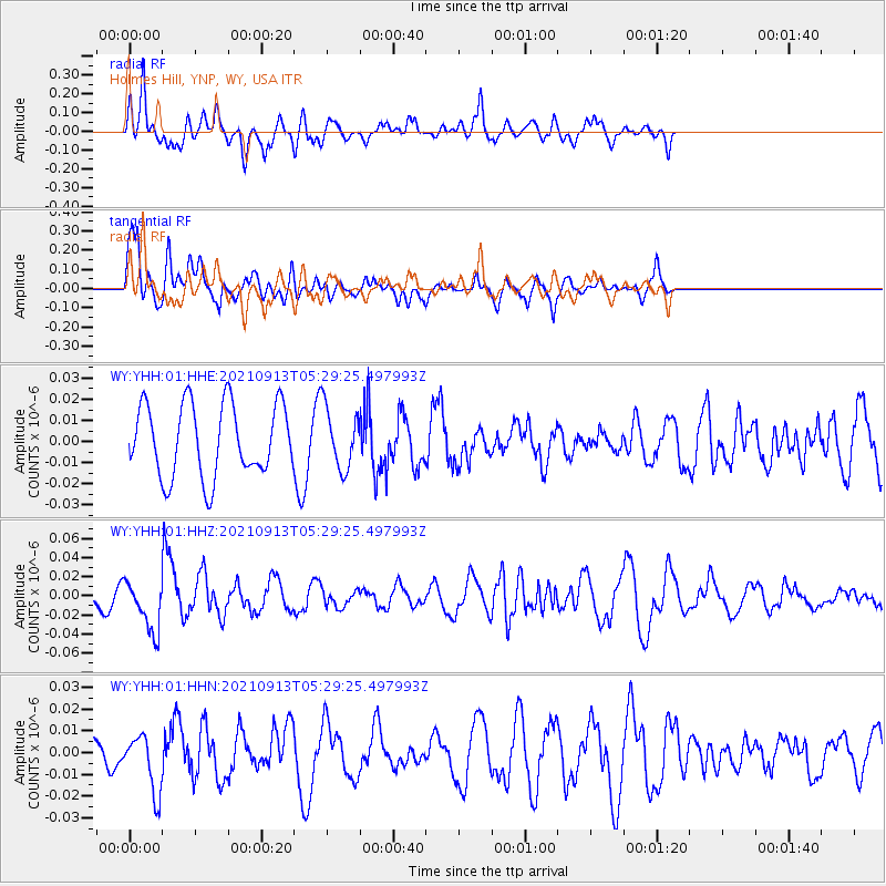
YHH Holmes Hill, YNP, WY, USA - Earthquake Result Viewer
*The percent match for this event was below the threshold and hence no stack was calculated.
| Earthquake location: |
Chile-Argentina Border Region |
| Earthquake latitude/longitude: |
-23.9/-67.0 |
| Earthquake time(UTC): |
2021/09/13 (256) 05:18:13 GMT |
| Earthquake Depth: |
193 km |
| Earthquake Magnitude: |
6.2 mww |
| Earthquake Catalog/Contributor: |
NEIC PDE/us |
|
| Network: |
WY Yellowstone Wyoming Seismic Network |
| Station: |
YHH Holmes Hill, YNP, WY, USA |
| Lat/Lon: |
44.79 N/110.85 W |
| Elevation: |
2717 m |
|
| Distance: |
79.2 deg |
| Az: |
329.863 deg |
| Baz: |
139.805 deg |
| Ray Param: |
$rayparam |
*The percent match for this event was below the threshold and hence was not used in the summary stack. |
|
| Radial Match: |
77.8817 % |
| Radial Bump: |
400 |
| Transverse Match: |
66.4092 % |
| Transverse Bump: |
400 |
| SOD ConfigId: |
25131211 |
| Insert Time: |
2021-09-27 05:43:41.977 +0000 |
| GWidth: |
2.5 |
| Max Bumps: |
400 |
| Tol: |
0.001 |
|
Signal To Noise
| Channel | StoN | STA | LTA |
| WY:YHH:01:HHZ:20210913T05:29:25.497993Z | 2.3228676 | 2.6743319E-8 | 1.1513062E-8 |
| WY:YHH:01:HHN:20210913T05:29:25.497993Z | 2.0334709 | 1.3110443E-8 | 6.447323E-9 |
| WY:YHH:01:HHE:20210913T05:29:25.497993Z | 0.8561468 | 1.4653706E-8 | 1.711588E-8 |
| Arrivals |
| Ps | |
| PpPs | |
| PsPs/PpSs | |


