You are here: Home > Network List > AV - Alaska Volcano Observatory Stations List
> Station AMKA Regional Station, Amchitka Island, Alaska > Earthquake Result Viewer
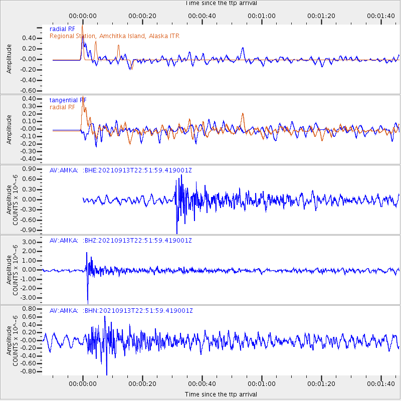
AMKA Regional Station, Amchitka Island, Alaska - Earthquake Result Viewer
*The percent match for this event was below the threshold and hence no stack was calculated.
| Earthquake location: |
Southeast Of Honshu, Japan |
| Earthquake latitude/longitude: |
32.4/137.9 |
| Earthquake time(UTC): |
2021/09/13 (256) 22:46:06 GMT |
| Earthquake Depth: |
376 km |
| Earthquake Magnitude: |
5.9 Mww |
| Earthquake Catalog/Contributor: |
NEIC PDE/us |
|
| Network: |
AV Alaska Volcano Observatory |
| Station: |
AMKA Regional Station, Amchitka Island, Alaska |
| Lat/Lon: |
51.38 N/179.30 E |
| Elevation: |
116 m |
|
| Distance: |
35.6 deg |
| Az: |
45.441 deg |
| Baz: |
254.045 deg |
| Ray Param: |
$rayparam |
*The percent match for this event was below the threshold and hence was not used in the summary stack. |
|
| Radial Match: |
54.95337 % |
| Radial Bump: |
400 |
| Transverse Match: |
54.042988 % |
| Transverse Bump: |
400 |
| SOD ConfigId: |
25131211 |
| Insert Time: |
2021-09-27 22:52:55.528 +0000 |
| GWidth: |
2.5 |
| Max Bumps: |
400 |
| Tol: |
0.001 |
|
Signal To Noise
| Channel | StoN | STA | LTA |
| AV:AMKA: :BHZ:20210913T22:51:59.419001Z | 12.374887 | 8.022978E-7 | 6.483273E-8 |
| AV:AMKA: :BHN:20210913T22:51:59.419001Z | 1.5812447 | 1.6667197E-7 | 1.05405555E-7 |
| AV:AMKA: :BHE:20210913T22:51:59.419001Z | 4.649272 | 3.3300552E-7 | 7.16253E-8 |
| Arrivals |
| Ps | |
| PpPs | |
| PsPs/PpSs | |


