You are here: Home > Network List > CI - Caltech Regional Seismic Network Stations List
> Station MPM Manuel Prospect Mine, California, USA > Earthquake Result Viewer
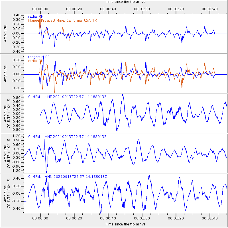
MPM Manuel Prospect Mine, California, USA - Earthquake Result Viewer
*The percent match for this event was below the threshold and hence no stack was calculated.
| Earthquake location: |
Southeast Of Honshu, Japan |
| Earthquake latitude/longitude: |
32.4/137.9 |
| Earthquake time(UTC): |
2021/09/13 (256) 22:46:06 GMT |
| Earthquake Depth: |
376 km |
| Earthquake Magnitude: |
5.9 Mww |
| Earthquake Catalog/Contributor: |
NEIC PDE/us |
|
| Network: |
CI Caltech Regional Seismic Network |
| Station: |
MPM Manuel Prospect Mine, California, USA |
| Lat/Lon: |
36.06 N/117.49 W |
| Elevation: |
185 m |
|
| Distance: |
82.0 deg |
| Az: |
52.363 deg |
| Baz: |
304.259 deg |
| Ray Param: |
$rayparam |
*The percent match for this event was below the threshold and hence was not used in the summary stack. |
|
| Radial Match: |
59.163635 % |
| Radial Bump: |
344 |
| Transverse Match: |
59.50273 % |
| Transverse Bump: |
316 |
| SOD ConfigId: |
25131211 |
| Insert Time: |
2021-09-27 22:58:24.975 +0000 |
| GWidth: |
2.5 |
| Max Bumps: |
400 |
| Tol: |
0.001 |
|
Signal To Noise
| Channel | StoN | STA | LTA |
| CI:MPM: :HHZ:20210913T22:57:14.188013Z | 1.6059827 | 5.8684896E-7 | 3.6541425E-7 |
| CI:MPM: :HHN:20210913T22:57:14.188013Z | 1.1444975 | 2.4103866E-7 | 2.1060653E-7 |
| CI:MPM: :HHE:20210913T22:57:14.188013Z | 0.78234565 | 2.2473365E-7 | 2.872562E-7 |
| Arrivals |
| Ps | |
| PpPs | |
| PsPs/PpSs | |


