You are here: Home > Network List > NR - NARS Array Stations List
> Station NE75 San Ignacio, Mexico > Earthquake Result Viewer
NE75 San Ignacio, Mexico - Earthquake Result Viewer
| Earthquake location: |
Tonga Islands |
| Earthquake latitude/longitude: |
-21.9/-173.8 |
| Earthquake time(UTC): |
2008/10/19 (293) 05:10:33 GMT |
| Earthquake Depth: |
29 km |
| Earthquake Magnitude: |
6.8 MB, 7.0 MS, 6.9 MW, 6.9 MW |
| Earthquake Catalog/Contributor: |
WHDF/NEIC |
|
| Network: |
NR NARS Array |
| Station: |
NE75 San Ignacio, Mexico |
| Lat/Lon: |
27.29 N/112.86 W |
| Elevation: |
137 m |
|
| Distance: |
76.6 deg |
| Az: |
53.126 deg |
| Baz: |
236.619 deg |
| Ray Param: |
0.05087261 |
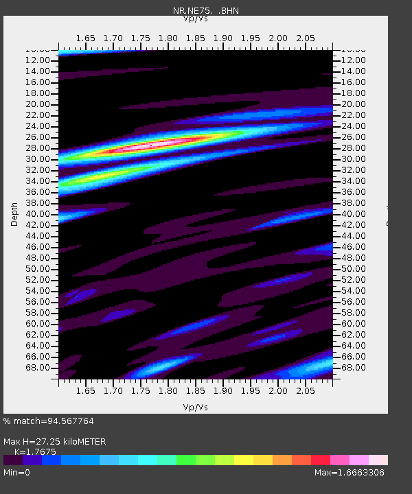
| Estimated Moho Depth: |
27.25 km |
| Estimated Crust Vp/Vs: |
1.77 |
| Assumed Crust Vp: |
6.276 km/s |
| Estimated Crust Vs: |
3.551 km/s |
| Estimated Crust Poisson's Ratio: |
0.26 |
|
| Radial Match: |
94.567764 % |
| Radial Bump: |
400 |
| Transverse Match: |
86.98669 % |
| Transverse Bump: |
400 |
| SOD ConfigId: |
2556 |
| Insert Time: |
2010-03-09 12:44:31.350 +0000 |
| GWidth: |
2.5 |
| Max Bumps: |
400 |
| Tol: |
0.001 |
|

Signal To Noise
| Channel | StoN | STA | LTA |
| NR:NE75: :BHN:20081019T05:21:50.326016Z | 70.164955 | 7.759128E-6 | 1.1058409E-7 |
| NR:NE75: :BHE:20081019T05:21:50.326016Z | 14.265667 | 1.6806368E-6 | 1.17809904E-7 |
| NR:NE75: :BHZ:20081019T05:21:50.326016Z | 11.704542 | 2.4817107E-6 | 2.1202972E-7 |
| Arrivals |
| Ps | 3.4 SECOND |
| PpPs | 12 SECOND |
| PsPs/PpSs | 15 SECOND |


